| FAMSI © 2005: David Wahl |
||||||
Environmental Change and Prehistoric Agriculture in the Mirador Basin
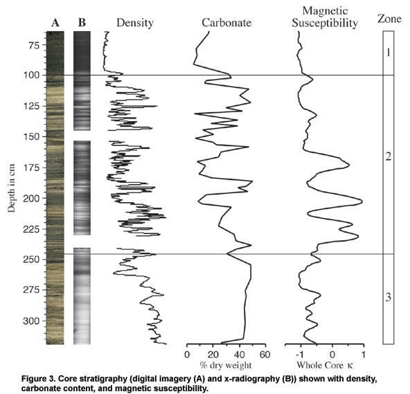
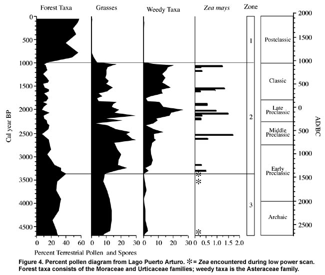
Results and Discussion For the purpose of discussion, results of the Puerto Arturo core analyses have been divided into three zones and focus on the mid to late Holocene. The age model is based on a fourth order polynomial fit (age = 0.00000003814068depth4 + -0.00008057484depth3 + 0.04855236depth2 + 6.278351depth + -42.17491) with R2 = 0.995. A basal date of >55,000 years indicates a hiatus of deposition between Pleistocene and Holocene sediment. Three dates have been excluded from the age model as they appear too old for their stratigraphic position. Results of core stratigraphy, density, LOI, magnetic susceptibility and pollen are presented in Figure 3, shown above, and Figure 4, shown below. The strong correlation between lighter colored portions of the core and carbonate content indicates that these layers represent calcareous marl. Moreover, carbonate rich layers show up as relatively dense sections in the x-ray images.
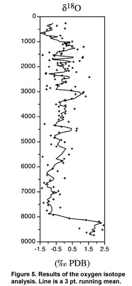
The sediment in zone 3 (3.18 to 2.46 m; ~4700-3400 cal yr B.P.) is characterized by fine banding of light/dark layers and relatively high (50%) carbonate content. Zea is present as a single grain near the bottom of this zone (3.15 m), and is not present again until the upper part of the zone, at 2.55 m. Herbaceous taxa (grasses and weeds) maintain stable, relatively low levels throughout zone 3. Carbonate content decreases in zone 2 (2.45 to 1.00 m; ~3400-1000 cal yr B.P.) and becomes more variable. Magnetic susceptibility values show three large peaks in zone 2, centered around 3100, 2600 and 2100 cal yr B.P., respectively. Two smaller peaks, at 1500 and 1000 cal yr B.P., follow. Non-carbonate inorganic percentages increase in this zone and positively correlate to magnetic susceptibility values. These curves undoubtedly reflect erosional input of upland clay into the lake. Carbonate content is out of phase with magnetic susceptibility in zone 2. The lower levels of zone 2 indicate an increase in herbaceous taxa coupled with a decrease in forest taxa. Around 2700 cal yr B.P., the forest taxa group reaches relatively stable, values of around 15% of the terrestrial pollen sum. Zea pollen is intermittently present throughout zone 2. The transition to zone 1 (1.00 to 0.15 m; ~1000-60 cal yr B.P.) is marked by an abrupt drop in density, inorganic content, and magnetic susceptibility values. It also exhibits a dramatic change in pollen frequencies. Forest taxa increase from 15% of the pollen sum at 1.0 m to 49% at 0.92 m. Herbaceous taxa, the dominant type of zone 2, abruptly drop to near zero values at the transition to zone 1. The chronology of maize agriculture set forth in this record can be used to clarify pollen records from larger, less sensitive lakes in Petén. Other pollen records from the Petén that include the mid Holocene show decreasing forest taxa from ca. 4000-2000 B.C. (Leyden 2002). Without concurrent evidence of agriculture, it has been difficult to isolate a cause for this decrease. Zea pollen at ~2650 B.C. in the Puerto Arturo core suggests that forest clearance by early agriculturalists was responsible. Changes in the local landscape correspond to the onset of sedentary village life. The pollen evidence shows an abrupt rise in grasses and weeds around 1450 B.C., concurrent with an accelerated decline in forest taxa. Similarly, the magnetic susceptibility indicates the first large pulse of erosion around 1400 B.C. (Figure 3 and Figure 4). Although populations must have been relatively small at this time, their land use practices had a clear impact on the environment. At least four more phases of increased disturbance alternating with periods of ecological recovery occurred during the following 2500 years. Disturbance phases are characterized by the presence of Zea pollen, peaks of disturbance taxa (grasses and weeds), and higher magnetic susceptibility values (Figure 3 and Figure 4). Recovery phases consist of a general reversal of this trend. Disturbance/recovery phases occur approximately every 500 years during the period of prehistoric settlement. The final recovery phase began ~1000 cal yr B.P. Three of the recovery phases are of particular interest. They correspond to the terminal phases of the Middle Preclassic, the Late Preclassic, and the Late Classic. Evidence of decreased disturbance at these times is present in multiple proxies from several sample levels, eliminating the possibility that they are statistical artifacts. Middle Preclassic Recovery Phase (540–350 cal yr B.C.) The Middle Preclassic recovery phase is characterized by a steep drop in grasses, weeds and agricultural indicators. Prior to this period, disturbance taxa and erosion reached a peak from ~700 to 540 B.C. Subsequently, clay input to the lake decreases abruptly until ~350 B.C. After 350 B.C., the trend reverses; grasses and weedy taxa increase, Zea is present, and erosional input dramatically increases. This recovery phase indicates a decrease in human activity in the local area. The timing of this recovery phase is important because it coincides with a period of cultural change in lowland Mesoamerica. The ceramics of the Middle Preclassic largely fall into the Mamon tradition. Around 300 B.C., however, there is a shift toward early forms of the ensuing Chicanel types that characterize the Late Preclassic. The homogeneity and distribution of Chicanel ceramics in the Late Preclassic, across the entire Maya lowlands, has contributed to the conclusion that this period may have constituted "the rise of the first state-level society in Mesoamerica" (R.D. Hansen in press). Moreover, shortly after this transition from Middle to Late Preclassic, many centers in the Mirador Basin experienced accelerated growth. The major structures at El Mirador were constructed at this time (R.D. Hansen 1990; Howell and Copeland 1989). Although there is no evidence for an abandonment in the Mirador Basin at the end of the Middle Preclassic, the Puerto Arturo record suggests that decline in population may have accompanied the cultural transitions indicated by the archaeological record. Late Preclassic Recovery Phase (cal yr A.D. 100–255) Archaeological evidence indicates a large population decline in the Mirador Basin at the end of the Late Preclassic (300 B.C. to A.D. 250). The most important site, El Mirador, was abruptly abandoned around A.D. 150 (R.D. Hansen 1990; Howell and Copeland 1989). Excavations show that few, if any, of these structures were later renovated or occupied during the millennia that followed. The abandonment of El Mirador and the surrounding area appears to have been relatively rapid and enduring (R.D. Hansen 1990:98-100, 216). Small populations occupied the region during the Late Classic period (A.D. 600-900), but did not rival the cultural apogee of the Late Preclassic period. The pollen data from Puerto Arturo corroborate this abandonment. The paleoenvironmental evidence for this abandonment is similar to that of the Middle Preclassic recovery phase. Increased values of grasses and weedy taxa, including maize pollen, from ca. 300 B.C. to A.D. 100, mark the intervening disturbance period. After A.D. 100, these taxa began a steep decline and minimum values persist from ~A.D. 130-225. Thus, it appears the Preclassic abandonment was underway shortly after A.D. 100. Anthropogenic disturbance in the watershed increases again around the beginning of the Classic period. Magnetic susceptibility and LOI data show a small increase in erosion during the Early Classic (Figure 3). Likewise, pollen indicates a coeval increase in disturbance taxa. All analyses show that disturbance was greater during the Late Preclassic than the Classic, possibly reflecting smaller Classic populations in the region. Late Classic Recovery Phase (cal yr A.D. 915–present) The Late Classic collapse is clearly present in the Puerto Arturo pollen record. An abrupt drop in grass, weed and agricultural pollen begins around A.D. 915. By A.D. 960, pollen from these groups, which had dominated the record for 2400 years, dropped to near zero values which persist to the present. The rapid change of pollen frequencies at this time is similar to changes in the Late Classic pollen record from Aguada Zacatal, near Nakbé (Wahl 2000). Forest recovery was also relatively rapid; pollen from arboreal taxa reached pre-disturbance levels within 100 years. Changing 18O/16O in biogenic carbonate of closed basin tropical lakes can be used to indicate changes in precipitation and evaporation (Covich and Stuiver 1974; Hodell, et al. 1995). Lake water becomes enriched in 18O (relative to source water) as 16O is selectively evaporated during periods of high evaporation/low precipitation. Past changes in lake water δ18O are recorded in carbonate shells as they precipitate.
The pollen record shows settlement and agricultural activity from ~4600-1050 cal yr B.P., which corresponds to the late Holocene dry phase. Zea pollen first appears ~4600 cal yr B.P. and is present off and on until ~1050 cal yr B.P., after which it drops out permanently. Pollen from grasses and weedy taxa shows an abrupt and sustained increase during this period. Although these increases may in part reflect drier climate, the concurrent presence of Zea during this period is strong evidence of anthropogenic impacts. Moreover, magnetic susceptibility (a proxy for watershed erosion) shows peak values corresponding to peaks in disturbance taxa pollen, further pointing to human agency. The highest values of disturbance proxies occur during the Late Preclassic (B.C. 300–A.D. 250), when the area was most heavily occupied (R.D. Hansen 1990, 1998). The Late Classic dry period that has been identified in the northern Maya lowlands (Curtis, et al. 1996; Hodell, et al. 2001; Hodell, et al. 1995) is reflected in the Puerto Arturo record from ~1300-1050 cal yr B.P. Inter-site differences in the timing of this event most likely represent the uncertainties of radiocarbon dating. It is important to note that this dry phase comes at the end of nearly 3500 years of relatively dry conditions and that pollen evidence indicates nearby agriculture in the area throughout the Late Classic (Figure 4). Agricultural activity apparently ended when more humid conditions set in ~1050 cal yr B.P. (A.D. 950). Within ~40 years after this date, weedy taxa drop to near zero values and Zea pollen disappears completely. The area has not supported large populations since. |
||||||
|
Text links to all pages at this site are available at the FAMSI INDEX |
||||||