| FAMSI © 2003: Charles Golden |
||
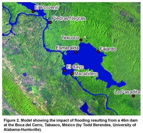
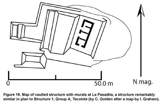
Sierra del Lacandón Regional Archaeology Project Conclusions The sites of Esmeralda and Fajardo are clusters of settlement situated to take advantage of the seasonally inundated bajos of the valley, and settlement at both sites clusters between approximately 100 and 140 m above sea level. Our hypothesis is that the bajos provided farmland for crops that supported not only local occupation, but the larger centers of the kingdom as well. Tests for the chemical signatures of maize agriculture conducted during the 2003 season by Kristofer Johnson of Brigham Young University may provide the evidence to support this hypothesis. Occupation at Esmeralda evidently continued from at least Late Preclassic through Terminal Classic periods. There is no reason to suspect that occupation in and around Fajardo does not reflect this same pattern. Some groups, such as PRASL 63, almost certainly functioned as local political nodes at these rural sites, and within the political scheme of the Piedras Negras kingdom such nodes may have occupied a third tier in the political hierarchy of the polity. Our ability to interpret the site of Texcoco is hampered by the lack of a ceramic sample. The poorly dressed masonry of the buildings suggests a late occupation, but we cannot say whether site occupation was contemporary with Piedras Negras or not. We can, however, say securely that Texcoco was a center of regional importance. The size of the architecture, the extent of the site, the presence of uncarved monuments, a vaulted sweatbath, and other features indicate the significance of the site. Furthermore, that the site is arrayed along a ridge top, accessible through narrow valleys, and situated on the flanks of the sierra suggests that Texcoco was built with defense in mind, although there is no reason to assume that this was the only reason for its placement on the landscape. If Texcoco was contemporary with dynastic Piedras Negras, it is almost certainly a secondary political center within the political hierarchy of the kingdom. If, however, Texcoco post-dates the dynastic power of Piedras Negras, the construction of this site on a ridge top may indicate a breakdown in regional stability, and political authority in the area may have been splintered. If this is the case, Texcoco may have been a primary center in a fractured political landscape. At Tecolote, however, we can be somewhat more secure in our dating of the monumental architecture and the site’s role in the political hierarchy of the region. On the basis of architectural form it is apparent that Structure 1 is a Late Classic building, with no earlier component apparent in looter’s trenches. There is no evidence for major modification of the substructure or superstructure, and the building was probably completed in a single construction phase. Tecolote is situated remarkably close to the site of La Pasadita, which we know to be part of the Yaxchilán kingdom. Various authors (e.g., Anaya 2001; Golden 2003; Golden et al. 1998) have suggested that La Pasadita was strategically located as a frontier outpost, used to control overland travel through the valley in which the site lies. Tecolote, too, was probably strategically placed to control both the local resources and maintain the frontier with the kingdom of Piedras Negras to the north. 8 With the continuing collaboration of the co-administration of the park and IDAEH, the Sierra del Lacandón Regional Archaeological Project hopes to continue its research from 2004 through at least 2009. Central to the goals of this project, as stated above, is the creation of a cultural inventory of sites in the Sierra del Lacandón that are endangered by the construction of a dam at the Boca del Cerro. If, as currently available information indicates, water floods the landscape behind the dam at the 136 m contour line, Piedras Negras will suffer serious damage and most, if not all, of Fajardo and Esmeralda will be flooded (see Figure 2, Endnote 2). The dam is scheduled for completion in 2009, and there is an obvious need for continuing research in the area to further document sites adjoining low-lying areas, and to rescue that information which can be rescued before rising floodwaters prevent any further investigations.
|
||
|
Text links to all pages at this site are available at the FAMSI INDEX |
||