| FAMSI © 2004: Matthew D. Moriarty |
||
|
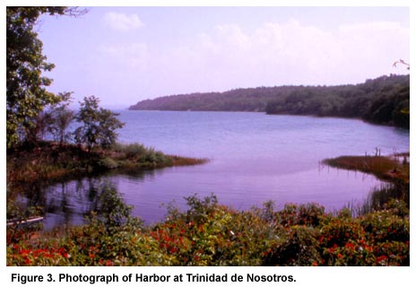
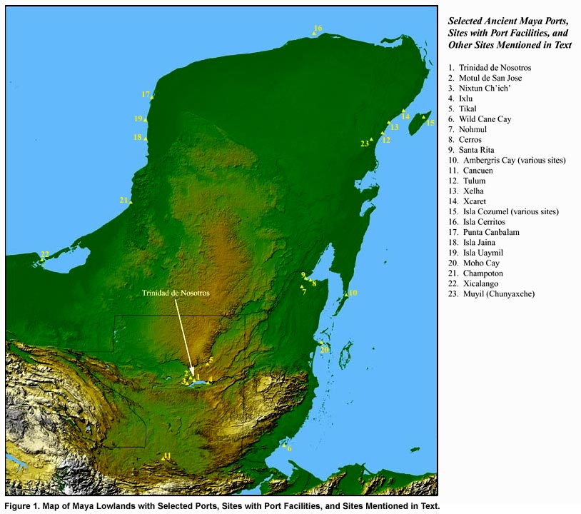
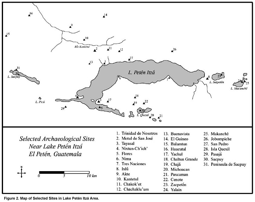
Investigating an Inland Maya Port: Trinidad de Nosotros: Location, History, and Previous Research The site of Trinidad de Nosotros (Sik’u’ in Itzaj Maya) is located on the north shore of Guatemala’s Lake Petén Itzá, approximately 3.5 km east of the modern town of San José and 2.6 km south-southeast of the Late Classic ceremonial center of Motul de San José (Figure 1). Located near the midpoint of the northern arm of Lake Petén Itzá (Figure 2), Trinidad was well positioned to participate in trade moving east-west across the lake. As Rice (1996) has identified port facilities and a series of possible inter-lacustrine canals at the east and west ends of the lake, this trade may have had considerable volume. Further, Trinidad is situated at the closest point of the lake to the Río Kantetul, a west-flowing stream that joins the larger Río San Pedro Mártir, an important artery of ancient Maya trade and transportation. Trinidad’s strategic placement is enhanced by the site’s natural setting. Sediments from a nearby drainage have created a relatively wide, silty beach at Trinidad that contrasts sharply with other locations on the north shore of the lake. Along most of the north shore of Lake Petén Itzá, steep natural terraces step down to narrow, rocky beaches, providing comparatively little space for beaching or loading or unloading canoes. In addition, a narrow, partially artificial peninsula at Trinidad extends out in front of the beach and creates a small, protected harbor (Figure 3, shown below).
During the mid-20th century Petén chicle boom, Trinidad was one of the principal chicle ports on Lake Petén Itzá. Chicle was transported from camps as far north as Uaxactún and Dos Aguadas to Trinidad where it was loaded into dugout canoes and barges for shipment to the island capital of Flores. Local informants indicate that Trinidad’s use as a chicle port resulted in part from its location at the base of a "natural path of least resistance" through the hilly terrain north of the lake. It is worth noting that the principal trail following this route passes within a few hundred meters of the principal plaza of Motul de San José. George Cowgill (1963:59) was likely the first archaeologist to visit Trinidad when he collected surface ceramics from a site he referred to as Playa Buena Vista. Based on his description, however, Playa Buena Vista was almost certainly the eastern portion of Trinidad de Nosotros. Trinidad was later visited by members of the University of Pennsylvania Tayasal Project including Stanley Loten and Arlen Chase. Chase (1983:1168) noted the presence of numerous mounds in the area including one mound eroding into the lake. In 1994, Rómulo Sánchez Polo and other members of the Proyecto Maya-Colonial performed a brief reconnaissance at the site, describing it as one of the major sites on the north shore of the lake (Sánchez 1996:152). Finally, in 2001, members of the Motul de San José Project carried out a brief reconnaissance at Trinidad (Moriarty and Wyatt 2002). A tape-and-compass map was prepared and ceramic materials were collected from the surface. Based on these investigations, Trinidad was identified as a major satellite center of Motul de San José and targeted for future research. |
||
|
Text links to all pages at this site are available at the FAMSI INDEX |
||