| FAMSI © 2004: Matthew D. Moriarty |
||
|
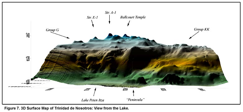
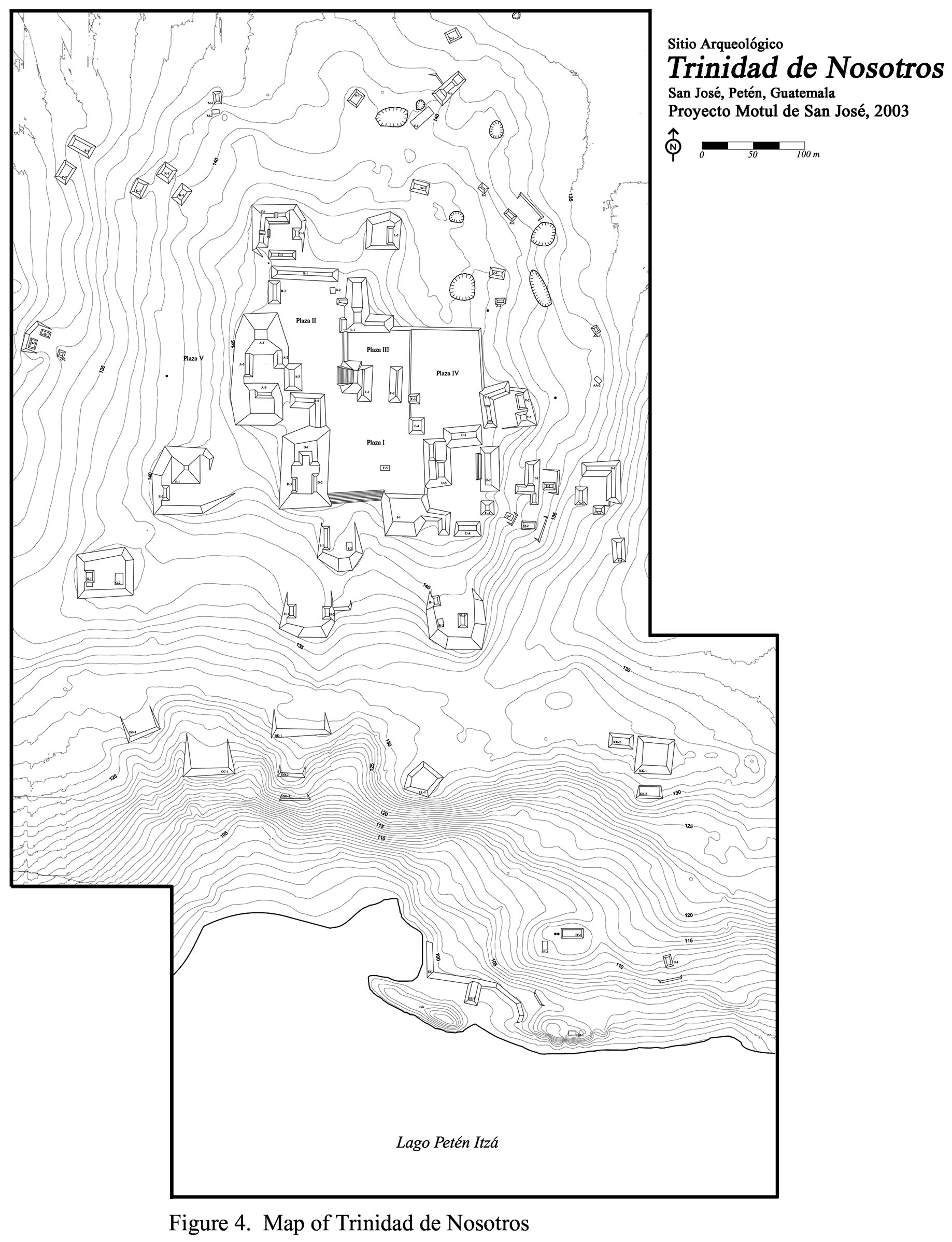
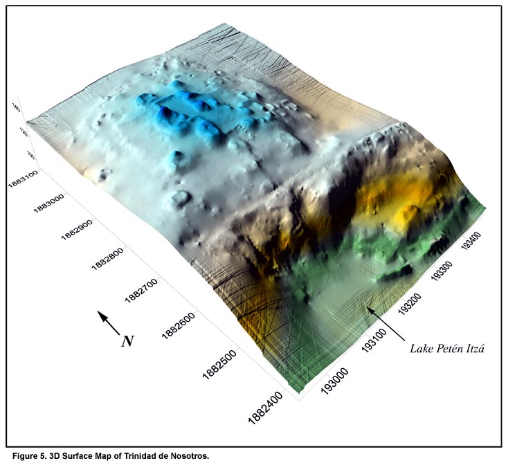
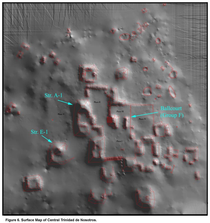
Investigating an Inland Maya Port: Investigations at Trinidad de Nosotros in 2003 The 2003 season at Trinidad was designed to collect a variety of baseline data concerning the site’s extent, organization, and chronology. From May to late July 2003, a series of archaeological investigations was carried out by a staff of seven American and Guatemalan archaeologists and students and a crew of eighteen workers from the town of San José. These investigations included survey and mapping operations, test excavations, a limited number of structural excavations, and preliminary explorations in Trinidad’s port area. The preliminary results of these investigations are described below. A more detailed summary will be available in the upcoming Motul de San José Project annual report (Moriarty, Foias, and Castellanos 2004). During the 2003 season, an area of approximately 35 hectares was surveyed and mapped (Figure 4). Based on field reconnaissance in areas surrounding the surveyed zone, the mapped area represents approximately 60-75% of the site of Trinidad. Large zones of settlement to the east, west, and north remain to be mapped. Within the surveyed zone, over 100 structures, eight quarries, and five chultunes were identified and mapped by the total station crew. Mapped architectural groups were given preliminary alphabetic designations in order of discovery. Numerous additional architectural groups were identified in the surrounding area. We estimate that upon completion of the final map in 2005, Trinidad will include 125-150 structures organized into approximately 50 groups. The mapped portion of Trinidad can be divided into two semi-discrete zones: (1) a densely settled core architectural zone atop the ridge overlooking Lake Petén Itzá; and (2) a slightly detached settlement area focused on the lake and the site’s harbor. The Core Architectural Zone: The core architectural zone at Trinidad de Nosotros is situated on the relatively flat summit of the ridge overlooking Lake Petén Itzá (Figure 5). Approximately 80 structures are located within this zone, most situated at least 40 m above the present lake level. The dominant architectural complexes within this zone are Str. A-1, Str. E-1, Group F, and a series of five public plazas (Figure 6). Structure A-1, a 12 m semi-radial pyramid, is the principal structure at the site and is clearly visible from distant parts of the lake (Figure 7). Str. E-1 is a slightly smaller temple that may have originally had a round form. Group F, the Trinidad ballcourt, has a T-shaped form and lateral structures 25 m long. The western lateral structure is surmounted by a small temple platform, referred to as the "Ballcourt Temple," accessible by a staircase on its western side.
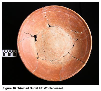
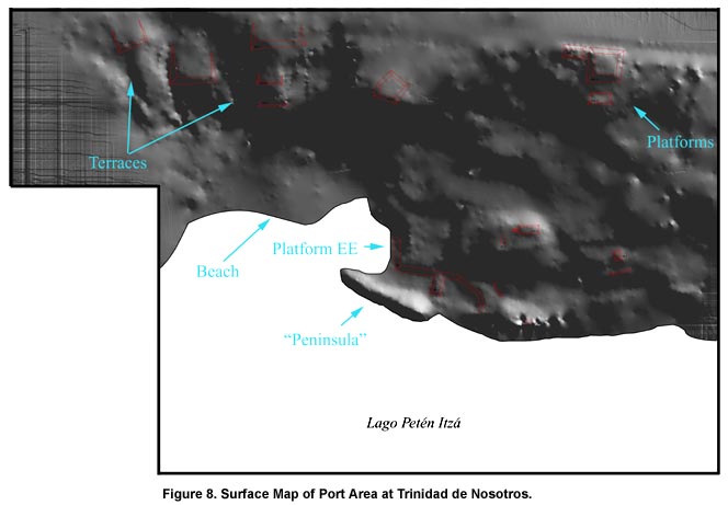
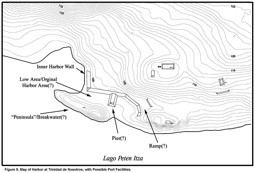
The core architectural zone at Trinidad is marked by the presence of numerous formal plazas. Four of these plazas, Plazas I-IV, are enclosed by the site’s principal architectural groups and residences and are accessible only by a staircase at the south end of Plaza I. Combined, these plazas cover an area of more than 9,500 m2. The fifth plaza, Plaza V, is located just west of the site’s principal structure and covers an area of more than 8,000 m2. Excavations in Plazas I-IV encountered multiple construction phases dating from the Preclassic to the Late Classic. Excavations in Plaza V, in contrast, revealed only sparse evidence for modification. Plaza V is identified as a plaza based on its location and the absence of visible surface architecture in what is, otherwise, the center of the site. Trinidad’s core architectural zone also includes a number of elite and commoner residences. Most of the residential groups located in close proximity to the site’s four paved plazas follow formal architectural arrangements and represent significant investments in labor. The principal structures in most of these groups–Groups C, L, S, T, U, and Y–probably originally had vaulted masonry superstructures and were likely residences for high status occupants of Trinidad. Based on test-pits, these groups were occupied primarily during the Late Classic. Slightly further from the site’s principal plazas, at least ten informal residential groups were mapped in 2003, although many additional groups remain to be mapped. These groups have extremely varied forms and, based on test-pitting, date to a variety of periods from the Preclassic to the Postclassic. The zone of settlement associated with the lake and the site’s harbor begins at the break between the flat ridge top and the slope down to the lake (Figure 8). At this interface, the ancient Maya constructed a series of terraces and platforms, most of which appear to have had perishable superstructures. Below this line of platforms and terraces, a series of natural terraces step down to the lake. Many possible terraces and low structures are located along this slope, but most have been left off the map of Trinidad until their identification can be confirmed by excavation. As with the slope leading down to the lake, Trinidad’s harbor presents a complex network of natural, artificial, and modified features (Figure 9). The principal features defining the port area are Platform EE, Platform GG, and an intervening low area. Platform EE is a 1 m high platform that runs along the lower edge of the slope leading down to the harbor. Platform GG, referred to as the "peninsula," is a 60 m long feature that extends out from the shore and defines the harbor. Combined, these two features are believed to have formed the inner wall and outer breakwater for the harbor that was originally situated in between. The low area between these two features is, at present, only a few centimeters above lake level and is frequently inundated. In addition to these features, Trinidad’s harbor may also have included a small pier and exit ramp. Str. EE-1, a low extension off of Platform EE, is well situated to have served as a pier. The possible harbor ramp is located at the east end of Platform EE where the platform slope is significantly more gradual than in other areas. An additional sloping terrace is located above this feature. Combined, these features may have facilitated the movement of canoes out of the harbor and into a low, flat area just to the east. During the 2003 season at Trinidad, a variety of different test excavations were carried out. First, a series of 29 1-×-1 m test-pits were excavated throughout the site in order to understand the site’s chronology. Second, a series of 273 postholes and 100 shovel tests were excavated to locate middens associated with residential groups. An additional series of 1-×-1 and 1-×-2 m pits were excavated in those areas with middens. The results of test-pitting operations indicate that Trinidad had an exceptionally long occupation, with major peaks occurring from the Middle Preclassic to the Early Postclassic. In Group G, for example, test-pitting recovered a long sequence of archaeological contexts dating to the Middle Preclassic, Late Preclassic, Late Classic, Terminal Classic, and Early Postclassic. A Preclassic burial (Trinidad Burial #5) was also recovered with marine shell pendants and a large, flaring-sided bowl, probably pertaining to a transitional Mamom-Chicanel ceramic complex (Figure 10, shown below).
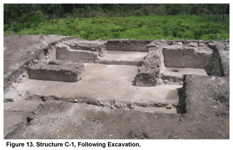
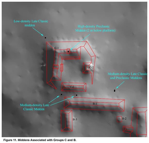
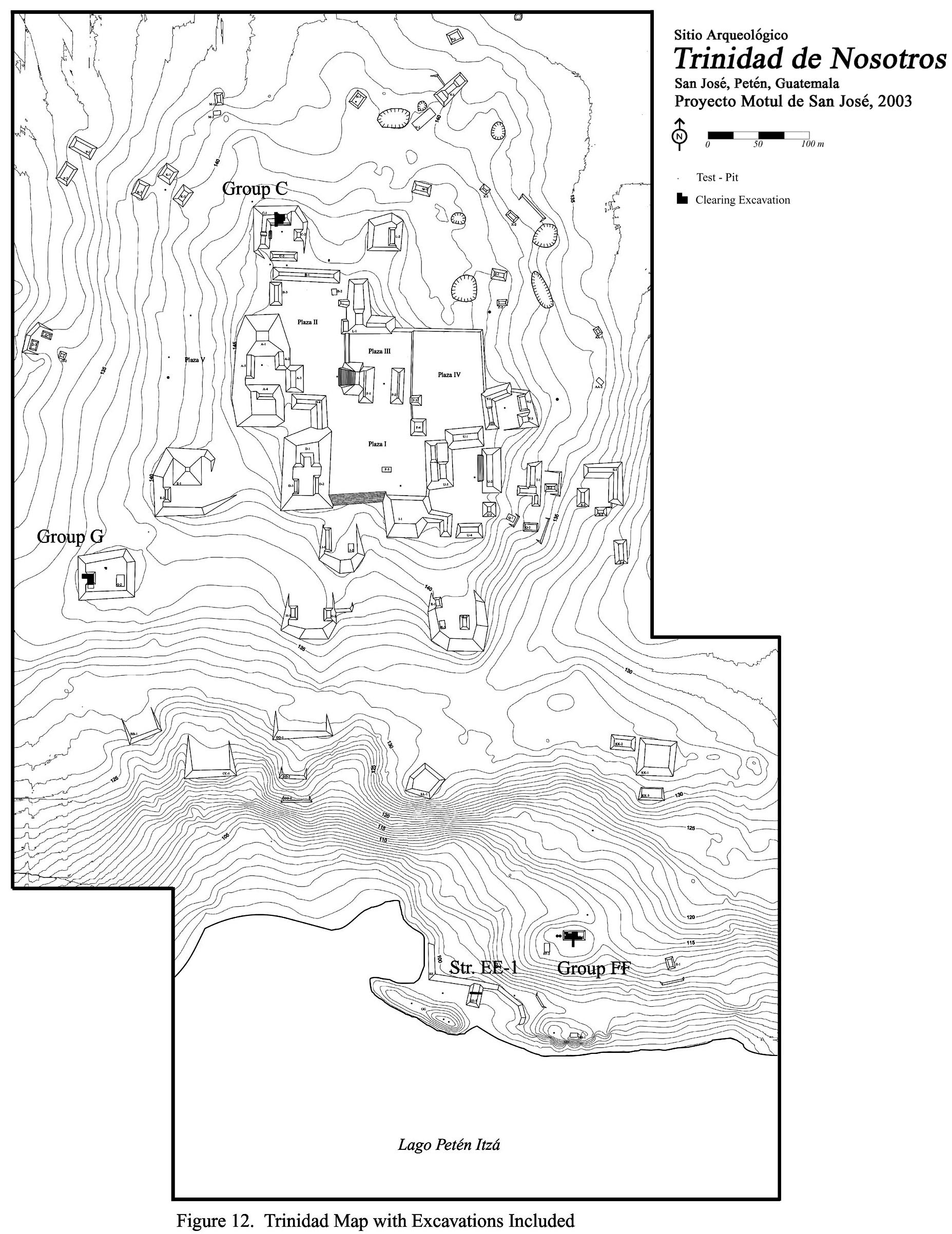
Investigations in 2003 were also successful in identifying a number of artifact-rich middens associated with residential groups. A variety of prospecting techniques utilized around Group C, for example, led to the identification of at least four separate middens with materials from the Preclassic to the Late Classic (Figure 11). Further analysis of these, and other middens located during future research will provide a reliable indication of access to trade goods critical to understanding Trinidad’s long-term port function. Three residential structures, Structures C-1, G-1, and FF-1, were wholly or partially cleared during the 2003 season in order to gain a better understanding of architecture and residential space at Trinidad (Figure 12). Investigations in Trinidad Str. C-1: Group C, the principal residential group at Trinidad, is located just north of Plaza II and Str. B-1. Trinidad Group C was constructed with a form corresponding to Tikal Plaza Plan 2, as defined by Becker (1971, 2003), with a small oratorio on its eastern side. Investigations in Group C focused on the eastern wing of Str. C-1, an L-shaped structure forming the north and west sides of the Group C plaza. A total of 48 m2 of the structure and adjacent terraces was cleared.
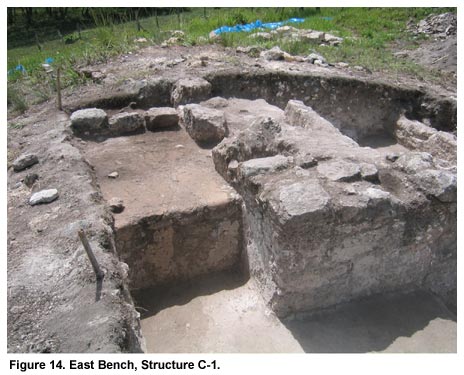
These excavations revealed that the eastern wing of Str. C-1 was originally a vaulted structure built in a tandem room arrangement (Figure 13, shown above). The front, or southern, rooms were open hallways while the rear, or northern, rooms were largely occupied by a pair of small benches (Figure 14, shown below). Access to the structure was achieved through a pair of wide doorways above a series of three terraces. Subsequent pits through the building’s final construction phase revealed it to be a Late Classic construction, although several possibly Terminal Classic modifications were also identified.
During the Late Classic period, the occupants of Group C were among the highest elites at Trinidad. This is indicated by both the quality of vaulted masonry architecture and the characteristics of artifacts recovered during excavations in and around the group. Although analysis of artifacts from excavations in Str. C-1 is ongoing, materials encountered there were among the highest quality found at Trinidad in 2003. The ceramic inventory included large numbers of polychromes and exceptionally well-made monochromes. Other artifact classes included numerous figurines and finished tools. Investigations in Trinidad Str. G-1: Trinidad Group G is located south of Plaza V and approximately 100 m north of the ridge-slope break. Group G is one of several residential groups located atop relatively massive basal platforms at Trinidad. Investigations in Group G focused on Str. G-1, a low rectangular structure on the west side of the Group G platform and an area of approximately 38 m2 was cleared.
Investigations in Structure G-1 revealed the structure to be a well-made foundation-brace structure, with a cut-stone foundation and interior stucco benches dating to the Late Classic (Figure 15, shown above). The structure was also occupied during the Terminal Classic when a number of major renovations were made. Subsequent excavations through the Group G platform revealed a long history of occupation dating from the Middle Preclassic to the Early Postclassic. Investigations in Group G also recovered outstanding evidence for chert tool production during the Late Classic, including enormous quantities of chert debitage, whole chert cobbles, and large numbers of chert cores, aborted tools, and broken and finished tools (Halperin and Hernández 2004). Chert tool production appears to have been a long-term specialization in the group as a transitional Middle-Late Preclassic midden, located atop bedrock under the platform, also included large quantities of chert debitage and microdebitage. Excavations in and around Group G also led to the recovery of more than 133 obsidian artifacts, suggesting that some obsidian tool production or other craft specialization involving obsidian blades occurred in the group.
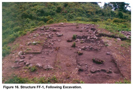
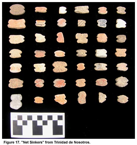
Investigations in Trinidad Str. FF-1: Trinidad Group FF is located atop a large natural rise directly overlooking the site’s harbor. Investigations in Group FF focused on Str. FF-1, the principal structure in the group, and an area of 28 m2 was cleared (Figure 16, shown above). Excavations revealed that Str. FF-1 originally had a packed-earth floor and perishable walls (Spensley 2004). Although Late Classic and earlier materials were recovered in association with this building, its final construction dated to the Early Postclassic. At least 28 notched sherds, normally interpreted as nets sinkers used for fishing (Figure 17, shown below), were recovered from within the structure, suggesting that the occupants of Group FF were focused on the extraction of lake resources during the Early Postclassic.
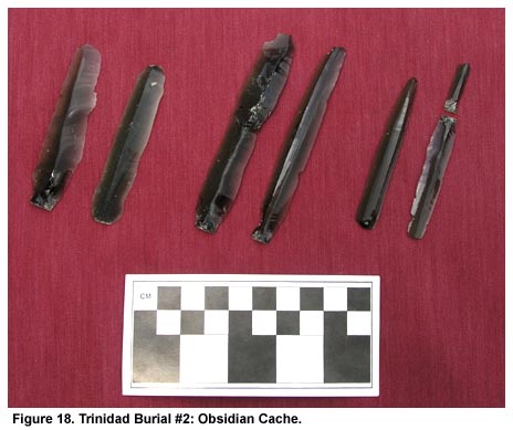
Excavations in the Port Area in 2003 As noted above, differentiating between natural, artificial, and modified features in the port area was relatively difficult during mapping due to the area’s long-term occupation and the effects of erosional processes. Thus, one of the principal goals of 2003 excavations in the port area was to determine which of the port features were man-made. These excavations demonstrated that the harbor at Trinidad is primarily an ancient Maya construction. Test-pitting confirmed that the inner harbor wall (Platform EE) is an artificial feature that was modified several times during the site’s occupation. The first construction of this feature dates to the Late Classic, and possibly earlier. Excavations on the "peninsula" also revealed a substantial degree of human modification. Test-pits on the eastern third of the "peninsula" located a preserved stucco floor, probably associated with a now completely eroded superstructure. In addition, a test excavation on the western two-thirds of the "peninsula" encountered massive fill stones mixed with a thick clayey matrix. This excavation also encountered a cache of six prismatic obsidian blades (Figure 18, shown below) and an associated burial (Trinidad Burial #2). Excavations in low area intervening between the "peninsula" and Platform EE, identified a relict lakebed below 75 cm of colluvium. Finally, excavation of the possible pier determined that it had been constructed in several phases with rough limestone boulders and well-prepared stucco floors.
|
||
|
Text links to all pages at this site are available at the FAMSI INDEX |
||
