| FAMSI © 2005: Jason Yaeger |
||
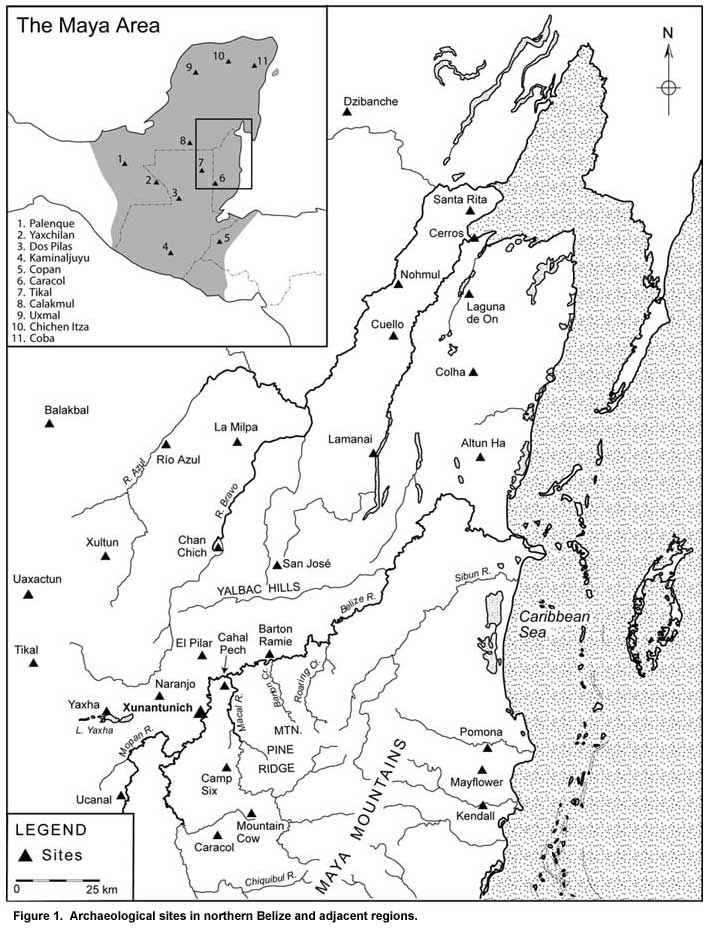
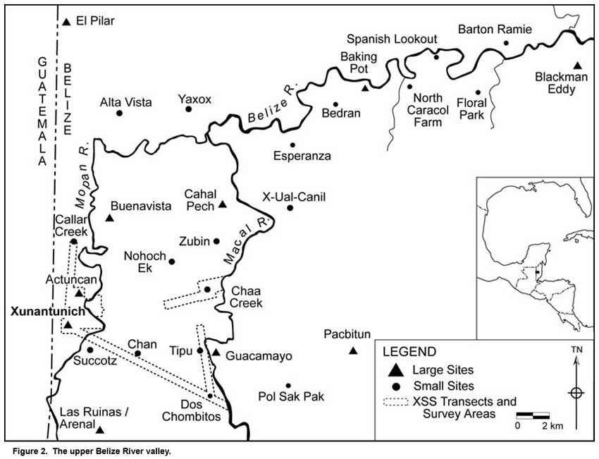
Revisiting the Xunantunich Palace: The 2003 Excavations Xunantunich and the Upper Belize River Valley Xunantunich overlooks the fertile floodplain of the Mopan River in western Belize, dominating visually the Mopan valley in the same way that the site’s rulers once dominated the region politically (Figure 1). Seven seasons of survey and excavation in and around Xunantunich by the Xunantunich Archaeological Project (XAP), directed by Richard M. Leventhal and Wendy Ashmore (2004; LeCount et al. 2002), confirmed that Xunantunich rose to political prominence relatively late in the history of the upper Belize River valley. Despite some earlier occupation, the site as it existed in the Late and Terminal Classic periods was founded around the beginning of the Late Classic period, during the Samal phase (A.D. 600-670; see LeCount et al. 2002 for the site’s chronology) and then expanded rapidly during the following Hats’ Chaak phase (A.D. 670-780). The founding and early growth of Xunantunich occurred within a political landscape characterized by powerful competing polities (Leventhal and Ashmore 2004; LeCount and Yaeger 2003). As can be appreciated on Figure 2, the landscape was densely packed with centers like Arenal (Taschek and Ball 1999), Buenavista (Ball and Taschek 1991, 2001, 2004), Cahal Pech (Awe 1992; Healy, Cheetham, et al. 2004), Baking Pot (Audet and Awe 2004), El Pilar (Ford and Fedick 1992), and Pacbitun (Healy 1990; Healy et al. 2004), powerful Classic-period polities that had deep historical roots and thus were presumably strongly embedded in local social, political, and ideological institutions (NB: Taschek and Ball [2004] argue that Xunantunich, Buenavista, and Cahal Pech were functionally differentiated sites within a single polity). Thus it is interesting that the powerful kingdom of Naranjo appears to have been linked closely to Xunantunich’s rapid Hats’ Chaak growth. The upper Belize River valley’s rich alluvial soils and its strategic location along the main route for Petén-bound canoe traffic from the Caribbean likely account for the efforts of the Naranjo ajawo’ob to control this area, indirectly or directly, especially during the reign of K’ak’ Tiliw (Ashmore 1998; Awe, personal communication 2002; Audet and Awe 2004; Ball and Taschek 1991; Houston et al. 1992; LeCount and Yaeger 2003; Taschek and Ball 1992). It remains unclear as to whether Naranjo’s relationship with Xunantunich entailed the insertion of a cadet lineage or other noble family from Naranjo to rule the site, foreign support of a loyal local elite family, or some other mechanism. Regardless of the details, the rulers at Xunantunich still had to establish and legitimate their place in the local socio-political context of the upper Belize River valley (Ashmore 1998; Yaeger 2004). The site itself testifies to their success: the labor required to complete the ambitious Hats’ Chaak building programs and the rapid pace of construction demonstrate that the rulers controlled labor from a relatively large area. The rapid increase of the power of the rulers of Xunantunich raises interesting and important questions about the polity’s political organization and the nature of authority and legitimacy at Xunantunich and other medium-sized Maya centers. The architectural and artifactual data from the palace compound at Xunantunich help document the changing political organization of Xunantunich over the course of the Late and Terminal Classic periods and the ways in which political authority was legitimated. |
||
|
Text links to all pages at this site are available at the FAMSI INDEX |
||