| FAMSI © 2007: William R. Fowler |
||
The End of Pre-Columbian Pipil Civilization, Ciudad Vieja, El Salvador
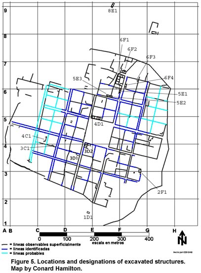
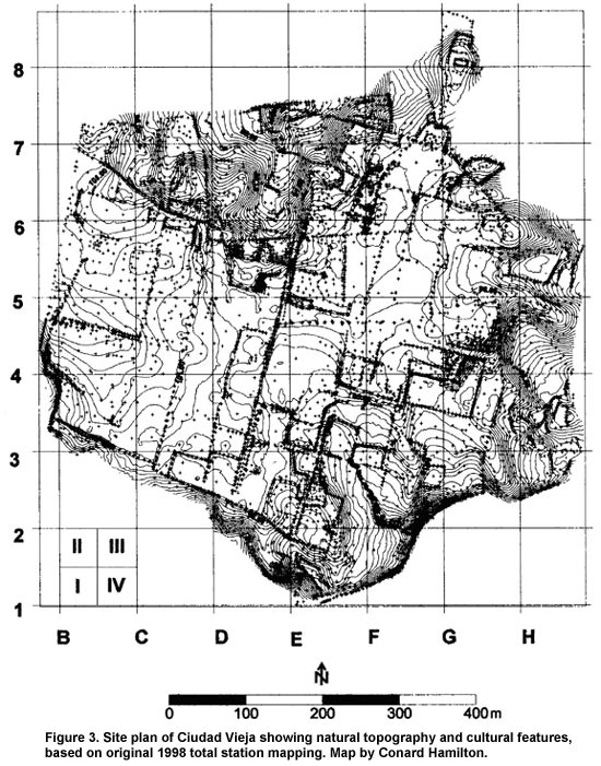
Excavations and Architecture The analytical sections on ceramics and chipped-stone artifacts include references to excavated structures. For the sake of clarity, we include here a brief descriptive summary of the excavations and architecture of the most important structures. A total of 13 structures and five associated activity areas were excavated in seven field seasons from 1996 to 2003 (Figure 5, shown above). Unless otherwise specified, the orientations of the buildings follow the general site grid of 12°. The multicourse stone wall foundations are usually 80-85 cm in width, or approximately one Spanish vara of 83 cm, although some foundations were thicker, in the range of 100-120 cm. The foundations run very deep, usually to at least 1 m below the uppermost course of stones. The width and depth of foundations were correlated with the width and height of the walls supported. The stones were generally carefully cut with at least one dressed face, laid carefully to form noticeably straight foundations. Walls were generally constructed of tapia or rammed earth, but in some cases adobe bricks were used. Floors were either earthen or covered with baldosas (brick floor tiles); occasionally cobblestones arranged in decorative patterns were used. Roofs were thatched or covered with tejas (ceramic roof tiles) laid over a wooden framework. Structure 4D1 The first structure to be excavated in the 1996 season was the substructure platform of the cabildo or town hall building, designated Structure 4D1. The interpretation of this structure as the cabildo is based on the known locations of cabildos in other Conquest-period Spanish American towns, usually on the north side of the plaza. In some cases, municipal buildings were located on the south or the west, but we have no good candidates for the cabildo on those sides of the plaza at Ciudad Vieja. Located at the northwest corner of the main plaza (Figure 3), this is an elongated, rectangular platform measuring 8 m in width (north-south), 32 m in length (east-west), and 1.3 m in height above the surrounding plaza. The structure is oriented at 12°. The entire summit of the platform was stripped clear of its shallow overburden, revealing the foundations and floors of four interior rooms. One room was paved with cobblestones and another with baldosas, while the other two, probably for storage, had earthen floors. The platform faces south, with steps on that side leading down to an open space bordering the north side of the plaza. These steps were constructed in and around a series of large andesite boulders that were incorporated into the construction and also formed part of the interior fill. We know of no Spanish civic structure that was built in this way, and this would appear to be an indigenous building technique. Likewise, the linear, rectangular shape of the platform is reminiscent of Postclassic structures in central El Salvador. Additional excavations of the cabildo platform were conducted for CONCULTURA by Roberto Gallardo in 2001 and 2002 and Herbert Erquicia in 2003. They discovered an earlier construction level below the platform, lending support to the hypothesis of the 1525 settlement of the first villa in this location. Structure 6F1 During the 1998 and 1999 seasons, excavations focused on four structures in the 6F quadrant, in the northern sector of the site that appears to have been a high-status Spanish neighborhood. This zone of the site was chosen for extensive excavation in order to attempt to identify the range of activities within a single neighborhood outside of the center of the city. The structures were contained within a single solar and built on top of an extensive terrace which covered the entire solar. Excavation of Structure 6F1 was directed by Roberto Gallardo of CONCULTURA and the University of Colorado. Located approximately 200 m north of the northeast corner of the main plaza, this was a large elite Spanish residence with sleeping rooms, an interior courtyard, and storage facilities. The structure was polygonal in shape, with the exterior walls measuring 44.2 m on the east, 18 m on the north, 33.4 m on the west, and 20.15 m on the south. The east wall was oriented at 12°, but the other walls varied somewhat from the overall site orientation. The main exterior entrance faced east toward a street that ran north-south in front of the structure, with a secondary entrance on the south. The entranceway floor was paved with cobblestones. Most of the interior patio was floored with baldosas and roofed with tiles, as were the three rooms on the north. The latter are interpreted as sleeping rooms. Four rooms on the west wing of the structure showed no evidence of baldosas or roof tiles, leading to the inference that they had earthen floors and thatched roofs. These are interpreted as storage rooms, probably for the storage of tribute commodities. Structure 6F2 This structure, located just to the north of Structure 6F1, was excavated by Fowler in 1998. It is rectangular, composed of three rooms aligned east-west. Overall exterior dimensions are 7.4 m in width (north-south) and 19 m in length (east-west). The central room contained the remains of an artesanal iron-working furnace, iron slag and debris, carbon, and ash. A number of finished iron objects such as a horse bit, a chisel, and many nails were recovered. The function of the other two rooms could have been for storage or sleeping, but almost certainly associated with the activities of the blacksmith who worked and likely lived here. An open gallery with a tiled roof was attached to the north side of the structure. This could have been a stable. We hypothesize that the iron working here was under the patronage of the high-status resident of Structure 6F1. Structure 6F3 Excavated in 1999 by Georgia West of SUNY-Albany, this small structure was discovered in test excavations on the east edge of the 6F terrace, approximately 60 m to the east of the principal entrance of Structure 6F1. Two small adjacent rooms were revealed, one measuring 6 × 12 m (east-west) and the other 4 × 7.8 m (north-west). One of the rooms contained the intact remains of a large earthen beehive-shaped oven filled with carbon and sherds. A dense sheet midden was found eroding from the base of the east edge of the terrace. These findings lend further support to the possibility of the 1525 settlement being in this location. Structure 6F4 Excavated during the 1999 season by Card, this structure was located directly in front of and across a narrow street to the east of Structure 6F1. The central room of a west-facing multiroom structure was excavated. Its dimensions were approximately 7.5 × 10.5 m, with the long axis running north-south. The room had an earthen floor and thatched roof. A zone of the earthen floor was burned in the north end of the room, and the presence of a mano and metate, and sherds of several large plates attest to a function of this room as a food-preparation area. Furthermore, just to the south of the room, we discovered and excavated part of a midden deposit with a great many animal bones. Faunal species from this deposit identified by Elizabeth Scott of Illinois State University include pig or javalí (Sus scrofa/Tayassu tajacu), dog (Canis familiaris), rabbit (Sylvilagus floridanus), deer (possible) (Odocoileus virginianus), cattle (possible) (Bos taurus), chicken (possible) (Gallus gallus), turkey (possible) (Meleagris gallopavo), frog (Rana spp.), and catfish (Galeichthys spp.), indicating a varied protein diet. Since no kitchen area was found associated with Structure 6F1, we hypothesize that this room of Structure 6F4 served as the food-preparation area for the residents of Structure 6F1. Structure 1D1 This structure was excavated by Conard Hamilton with the intent of testing a possible non-Spanish structure. Located outside the city proper atop a small hill, approximately 40 m to the south of the south boundary of the formal grid plan and oriented at 20°, the structure measures approximately 6.3 × 7.3 m (east-west). It had a thatched roof and earthen floor. A significant concentration of obsidian artifacts recovered from this structure, including an arrow point, suggests the presence of Indian occupants. The absence of cooking/serving vessels and grinding stones would seem to preclude a domestic function. The location outside the city on a hill with a good view in all directions suggests a military function as an observation post, and the lack of Spanish-associated traits suggest that this structure was possibly manned by Tlaxcaltec troops. Structure 2F1 Situated on the eastern end of a terrace on the southern periphery of the site, barely within the eastern limits of the city proper, this structure, excavated by Conard Hamilton in 1999, is quite different from known Spanish structures closer to the center of the city. It has irregular dimensions, approximately 5.5 m north-south and 10.5 m east-west. The orientation of each foundation wall is also irregular with the east wall at 8°. Its foundations were formed by single rows of large, uncut stones. The roof was thatched, and the floor was earthen. Two spindle whorls were recovered from within the structure. Obsidian artifacts were prevalent here, including several arrow points. All these characteristics plus the location of the structure strongly suggest a non-Spanish presence. It is quite possible that the sector of the site was an indigenous barrio, but this possibility needs to be tested by further excavations. Structure 3D1 Excavated in 2001 by the authors, this was the first of several structures to be investigated on the southwest corner and the south side of the plaza where efforts are now being focused. Textual evidence suggests the presence of commercial structures "on the plaza" in San Salvador (Altman 1991), and we propose that they were located in this area. Located approximately 150 m south of the cabildo and just off the southwest corner of the plaza, this structure was initially identified on the surface by a very dense concentration of roof tile fragments. Approximately 50% of the structure was excavated. While the exact dimensions of the full structure are unknown at this point, the excavated portion measures approximately 12 m east-west and 20 m north-south. The orientation seems to conform to the overall grid plan of 12°. The structure was built on a very deep platform of solid stone construction running to a depth of 103 cm. No internal room divisions were found, suggesting a single, one-room, nonresidential structure. The roof was tiled, and the floor was adorned with deep red floor tiles forming a checkerboard pattern. All in all, the architectural features suggest a special-function structure rather than a residence, and a commercial function is a strong possibility. As discussed below, this structure has a high incidence of imported Spanish pottery (including a large number of olive jar fragments, a fragment of Columbia Plain majolica, and a Caparra Blue majolica drug jar), and it has the highest percentage of brimmed plates associated with it, making up 29% of all vessels with an identifiable form. Structure 3D2 The subsurface remote sensing conducted in 2002 indicated numerous linear and rectilinear anomalies representing a street and a number of structures on the south side of the main plaza (Bales, Reynolds, and Kvamme 2003; Reynolds and Bales 2003). Recognition of these features substantially changed our view and understanding of the plaza, and, more importantly, none of them was visible on the surface. Especially interesting was an apparent structure with three rooms in a north-south alignment forming the interior southwest corner of the plaza and a series of attached rooms to the east. Excavations began here, directed by Fowler, in January 2003. We found another blacksmith's shop on the southwest corner of the plaza, an adjacent food-preparation area and charcoal manufacturing area to the east, and a street that enters the southwest corner of the plaza, turns at the corner of the blacksmith's shop, and runs toward the southwest corner of the church platform. This cluster of rooms was designated Structure 3D2 (Figure 5). The blacksmith's shop on the corner measures approximately 18.5 m north-south and 6.7 m east-west. The furnace was located in the northern room. It was associated with a long, narrow tempering tank constructed in the floor, apparently for tempering swords. Adjoining this structure was a large, open room measuring 12.2 m east-west and 7.1 m north-south. Here we found a number of partial and complete cooking and serving vessels. Smaller rooms continue to the east. We interpret this cluster of rooms on the south side of the plaza as a market/industrial area producing and selling iron tools and weapons, food, and probably many other items as well. |
||
|
Text links to all pages at this site are available at the FAMSI INDEX |
||