| FAMSI © 2005: Marcie L. Venter |
||
Totógal: Investigations of Postclassic Occupation and the Aztec Frontier in the Tuxtla Mountains, Veracruz, México Site Description Totógal is situated at approximately 300 m asl on the southeastern slopes of Cerro el Vigía, a dormant volcano immediately west of Santiago Tuxtla (Figure 2, shown below). The site is less than 2 km upslope from the small town of Sehualaca. Several looters’ pits impact stone architecture at the site and the displacement of walls suggests that dynamite was used (Ponciano Ortíz, personal communication, 2004). Today the site is divided among four property owners.
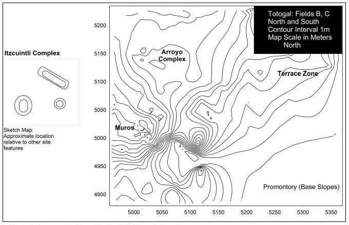
Totógal extends 300 to 400 m from north to south, and roughly 1 km west to east (Figure 3, shown below). A promontory in the southeast corner of the site offers a commanding view of the Tepango (Tuxtla) river valley, which would have been advantageous if defense was a concern (Carrasco 1999; Gerhard 1993; Paso and Troncoso 1905).
Steep slopes on the north, east, and south sides, and uneven, volcanic surfaces at the western fringes of the site served as natural limits to site growth. Artifact distributions suggest this, as does the far western terrain, which is punctuated by two volcanic cones. Nearly all portions of the site are within 150 m of year-round water sources, though water availability may have differed in the past, before deforestation of the area. Visible architecture includes earthen mounds, stone foundation walls and altered natural landforms (Figure 4). Construction and landform modifications are dispersed across the site but with some localized clustering in the west, center, north and east. The named zones roughly correspond to property divisions so that Field A = the western "Itzcuintli Complex"; Field B = the central "Muros Zone"; Field C North = the northern "Arroyo Complex"; and Field C South = the eastern "Terraza Zone". Field D has low artifact densities and contains no architecture. A four-meter high conical mound dominates the "Itzcuintli" complex (Figure 5, shown below). A long mound lies twenty meters to its immediate north and measures approximately 60 m from west to east and 20 m from north to south. This was a natural terrace and its slopes were reinforced by basalt retaining walls, particularly on the north side, which drops suddenly to an arroyo 30 m below. Another modified landform sits approximately 50 m to the west of the conical mound. It has stone reinforced walls and its top has been leveled. These retaining walls prevent erosion into a tree-filled gully to the south.
A natural spur begins 75 m east of the Itzcuintli complex and forms the central "Muros" zone. This natural feature has been reinforced on its north, east and south slopes. It also functions as a platform for multi-roomed stone structures. Only the most recent construction phase is easily observed (Figure 6, shown below). This later building phase used a different technique of construction from the underlying foundations: porous basalt blocks adhered with sand, clay, and shell mortar. The lower structure was made with less porous dry-laid basalt cobbles and small boulders (Figure 7, shown below). The lower structure sits directly on the tepetate, or volcanic substratum, which was reached at approximately 65 cm below ground surface.
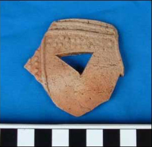
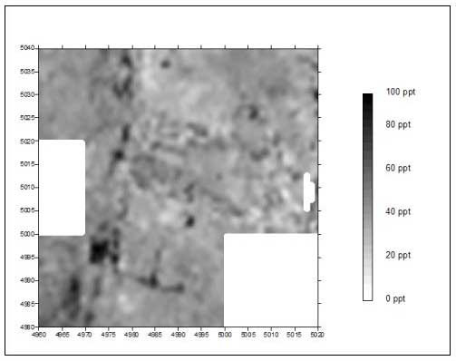
Four looters’ pits are located on the platform. The cleaning of profiles in two of these pits yielded several elaborately decorated ceramics (Figure 8), but surprisingly, no colonial materials. 2 Substantial wall fall confuses the architectural pattern, but conductivity over this area provides a rough blueprint of the extensive construction (Figure 9). A low rise sits south of the platform and yielded high densities of materials. Approximately 20 m farther east there is a small volcanic cone. Its leveled top and artifacts near its base suggest that it was utilized. A series of artifact concentrations lie to the northeast of the Muros Zone. They sit on relatively level terrain, which terminates in a series of terraces in the east. No mounds or landform modifications are located here, but we recovered high densities of daub and a few buried rock alignments that, together with artifact distributions, suggest a residential function for the area. A permanent stream that flows from west to east provides the northern border for this locale. To the north of the arroyo sits the small "Arroyo" mound complex. The small 3 m high conical mound in this area is artificial. Another low rise sits approximately 10 m to the east-southeast. This feature is less than a meter high and the density of materials recovered on it is high. The eastern slopes of the site, the "Terraza" zone, are stepped and supported additional occupation. On the first terrace step and close to the northern arroyo, artifact densities are high; however, they appear to decline dramatically in the areas further down slope to the east and south. The slope overlooking the arroyo is retained artificially with small basalt boulders that may include steps that descend to the water.
|
||
|
Text links to all pages at this site are available at the FAMSI INDEX |
||


, looking west from Muros.")
.")
