| FAMSI © 2005: Andrew R. Wyatt |
||
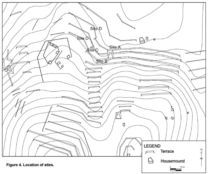
Excavations on Agricultural Terraces: Results of the 2004 Field Season at Chan, Belize Results of 2004 Excavations Excavations were carried out in four different locations: Site A, Site B, Site C, and Site D (Figure 4). Site A excavations were centered around Structure C-304 and Sites B and C were located approximately 25 m from the structure. Site D is actually several sites clustered nearby each other and represents the explorations of several small depressions. Excavations at structure C-304 revealed a complex series of constructions episodes ending in a Late to Terminal Classic (A.D. 600-900) household (Wyatt 2004). This structure is somewhat unusual in that it is a fairly large structure (3 m in height on the north side) with a long history, yet exists without any adjacent structures; single mounds are not unusual in this area, but it is rare for them to be this size and to have multiple construction episodes. The structure also sits on a hillside connected to several terrace walls and most likely served as a focal point for agricultural activities. However, the truly unique nature of this structure is in its earliest incarnation as a "springhouse".
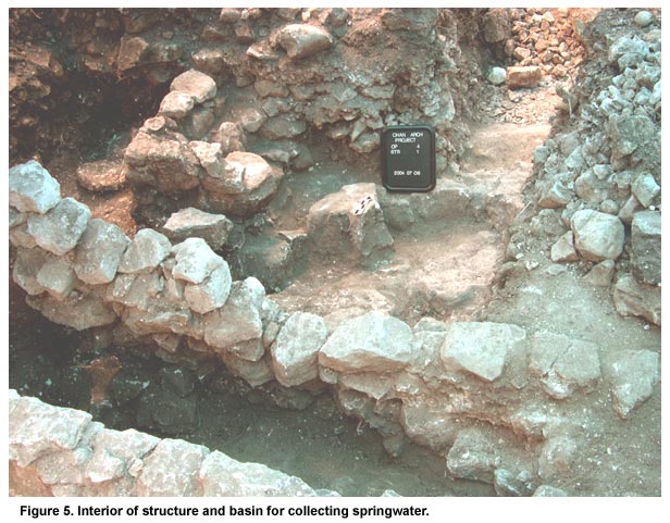
Excavations on the terrace beds and terrace walls adjacent to the structure on the east revealed a natural spring (now dry) emanating from the side of the hill near the southeast corner of the structure. The spring was diverted to the agricultural terraces as well as into and through the earliest construction of the structure. Bedrock was cut and stones were set in place to guide the spring from its origin through a small opening in the wall of the structure at the far southeast corner. Once inside the structure, the water was guided through the interior and was collected in a small pool or basin created by the placement of large stone blocks (Figure 5, shown above). This basin also had a small spillway that would guide the excess water away from the structure.
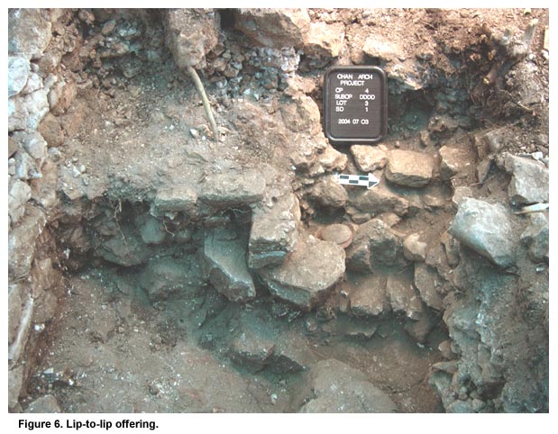
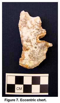
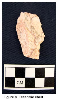
While the exact function of this structure is unclear, its focus was certainly the collection and maintenance of springwater. Whether it was to create a climate-controlled food storage facility or to collect water for drinking (or, most likely, both) it represents an extensive knowledge and use of the hydrology in this locale. Interestingly, indicators of a ritual function for the springhouse are minimal. No burials were found associated with the structure, and no ritual paraphernalia were found. However, near the water basin is an offering of three lids; two set lip to lip with a third atop those (Figure 6, shown above). On either side of this ceramic offering were two eccentric cherts (Figures 7 and 8, shown below).
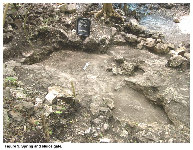
Also, in the SE corner of the structure, a similar offering, but without the eccentric chert objects, was placed upon the sealing of the early structure. Offerings of lip-to-lip vessels are common throughout the Belize River Valley, and while there was certainly ritual associated with the construction and subsequent building episodes of the springhouse, there appears to be no particularly important ritual function. As mentioned above, the spring also served to irrigate the terrace beds adjacent to the structure as well. A natural sluice gate carved into the bedrock just below the source of the spring guided water through the terrace wall and the terrace bed (Figure 9, shown below).
Underneath the ultimate terrace wall construction at the southeast corner of the structure were three small stone walls following a 50º NE angle; the angle of the natural uplift of the bedrock. These angled walls most likely guided the springwater to the terrace bed below, after passing through the sluice gate. The spring therefore served a dual purpose; to irrigate the nearby terraces and to supply water for the springhouse. However, at some point the spring either dried up completely, or failed to provide enough water to warrant the continued maintenance of a springhouse. Later construction episodes filled in the interior channels and basin of the springhouse, and the exterior channels were filled in as well. A later terrace wall was then constructed over the angled walls.
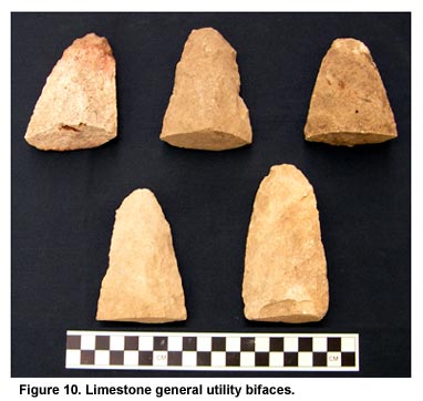
A total of 22 general utility bifaces were also recovered throughout the excavations in the structure, either in fill or in middens (Figure 10, shown above). Made of limestone or poor-quality chert, the size and form of these implements suggest an agricultural function, similar to a modern-day hoe. This structure therefore has served both an agricultural purpose as well as a water management function, and represents localized control of resources.
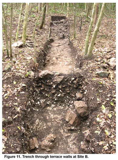
A trench excavated through two cross-channel terrace walls and three terrace beds at site B revealed unique construction techniques as well as evidence of an earlier terrace wall on the terrace bed (Figure 11, shown above). The majority of terrace walls excavated in Mesoamerica consist primarily of a vertical facing wall of large stones or cut blocks with small fill piled behind the wall to facilitate drainage. Occasionally, walls will be constructed of two vertical walls of large stones with fill in between (this is the construction of the terrace wall at the northeast corner of structure C-304). While this form of terrace construction maximizes the planting surface on the terrace bed, it also requires a great deal of time spent on maintenance of the wall. During periods of high rainfall, hydrostatic pressure builds up and sections of the wall will collapse. The terrace walls at site B, however, were constructed with smaller stones, with the walls at a 45-degree angle to the planting surface. The excavation profile showing stones with quite a bit of soil mixed in indicates that these walls were most likely built accretionally over time with more stones piled against the wall as soil continued to accumulate through alluvial processes. Unlike the terraces at large sites such as Caracol (Healy 1983; Chase and Chase 1998) which were built with large vertical stones, the Chan cross-channel terraces resemble terrace construction associated with smaller households (Donkin 1979; Smith and Price 1994). The angled terrace wall would also save on maintenance as the wall would be less likely to collapse during periods of heavy rainfall. The 45-degree angle would serve as a buttress and create a much stronger wall. While not as aesthetically pleasing as a cut stone wall, such as one might want in the elite center of a city, the construction of angled terrace walls utilizing smaller stones is more functional and less time-consuming to maintain.
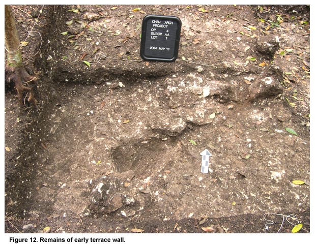
Located on the terrace bed between the two excavated terrace walls, we uncovered the remains of what is likely an earlier terrace wall (Figure 12, shown above). Although fragmentary, this line of stones resting on bedrock suggests that an earlier attempt to build a terrace wall was built over by later constructions.
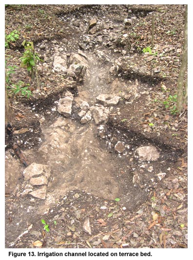
Excavations in this location were begun at the corner of two terrace walls, revealing an irrigation/drainage channel running across the terrace bed. At the corner, a series of stones were set in place to guide water down the wall of the terrace, and onto the terrace bed. From that point, a channel was created alternately with stones, cut bedrock, and natural bedrock features. Similar to the spring water channel at site A, this channel ran at a 50-degree northeast angle, again utilizing the natural topography (Figure 13, shown above). Originally we suspected that this was simply a channel to drain excess water, a necessity during the rainy season. However, a small pile of stones was placed directly in the channel at two points, resembling a water distribution system utilized by terrace farmers in Switzerland (Netting 1993). In this system, water is released from a reservoir located farther up the hill and allowed to drain down a channel. At various points, a barrier is placed in the channel, causing the water to pool and spread across the terrace bed, providing water for crops. A large series of reservoirs are located above the terraces on a plateau, possibly providing a water source for this particular irrigation channel. This provides the first evidence of small-scale irrigation of agricultural terraces in the Maya Lowlands. Much of the irrigation projects throughout Mesoamerica consist of large-scale public works projects such as the chinampas outside Tenochtitlán and the raised fields in Pulltrouser Swamp. What this demonstrates is that small scale farmers could and did create and maintain intensive agricultural systems away from centralized control. Scarborough (2004) shows how the Tikal elite controlled access to water for a large area surrounding the site core. In the hinterlands, however, similar systems were constructed and maintained by a non-elite farming populace.
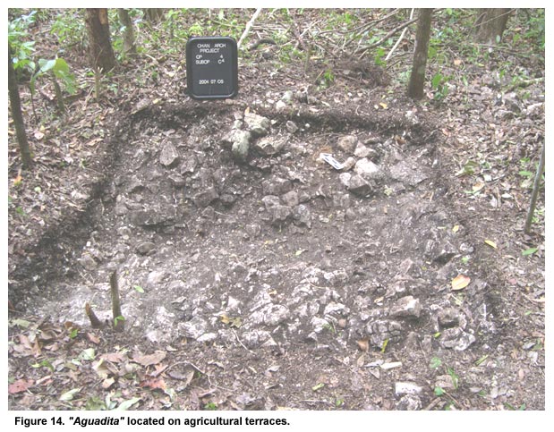
Site D is not one specific location, but refers to three excavations undertaken in what we have come to term "aguaditas" (Figure 14, shown above). Aguadita refers to a very small depression visible on the surface, often no more than 2 meters in diameter, and less than a meter deep. Originally we thought these were simply depressions created by tree fall, but closer inspection revealed they lacked the normal mound of dirt created by the uplifted roots on one side. Excavations revealed that of the three aguaditas excavated, two are unequivocally human-made structures with the other most likely an aguadita, but not definitely. We have called them aguaditas because we believe they were small water reservoirs for practicing "pot irrigation"; filling small containers with water and watering plants by hand. |
||
|
Text links to all pages at this site are available at the FAMSI INDEX |
||