| FAMSI © 2007: Charles Leonard Frederick Knight |
||
Palo Errado Patterned Wetland Mapping Project, Veracruz, México
Research Year: 2005 Table of Contents
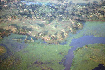
Abstract The possible remains of pre-hispanic patterned wetlands were detected on a 1:50,000 vertical aerial photograph of the Late Formative to Early Classic period site of Palo Errado, Veracruz, México in 2004. In order to better define these patterns, as well as potentially identify additional patterns, a series of low-altitude, oblique aerial photographs were taken of a 7,200 ± hectare area surrounding Palo Errado in February 2005. The subsequent analysis of the low-altitude, oblique aerial photographs indicated that the original patterns observed in the 1:50,000 vertical aerial photograph either did not exist, or had been obliterated due to recent agricultural activities. Nonetheless, three previously unidentified zones of possible wetland patterning were identified, as well as several large mounded sites. A surface reconnaissance was carried out to explore and map the zones of possible wetland patterning and the mounded sites. Once mapped, the patterns observed during the aerial reconnaissance were determined to date to the recent historic period, due to their systematic spacing and alignment. These modern patterns likely functioned as flood mitigation strategies. Finally, several large mounded sites that were identified were visited and mapped. En el año 2004 se detectaron posibles restos de campos inundables en el sitio de Palo Errado, Veracruz (México), el cual data del Formativo Tardío al Clásico Temprano, por medio de una fotografía aérea vertical a escala 1:50.000. En Febrero del año 2005 se tomó una serie de fotos aéreas oblicuas a baja altitud en un terreno de aproximadamente 7200 hectáreas alrededor del sitio con el fin de entender mejor la extensión de estos posibles campos, y de detectar otros que posiblemente existieran. El análisis de estas últimas fotos indica que los campos que parecían visibles en las fotos verticales no existen o han sido destruidos como resultado de actividades agrícolas recientes. Sin embargo, se identificaron tres zonas de posibles campos inundables que no habían sido detectadas con anterioridad, al igual que varios sitios grandes con montículos. Una vez digitalizados, los campos que se observaron durante el reconocimiento aéreo parecen estar sistemáticamente distribuidos y alineados, lo cual sugiere que posiblemente datan del período histórico reciente. Estos campos inundables modernos probablemente sirven la función de mitigar las inundaciones. Adicionalmente se visitaron varios de los sitios con montículos identificados, cuyo plan se dibujó. Click to download the report in PDF format: Palo Errado Patterned Wetland Mapping Project, Veracruz, México (1.04 MB) The PDF files require Adobe Acrobat Reader.
Submitted 07/26/2006 by: |
||
|
Text links to all pages at this site are available at the FAMSI INDEX |
||