| FAMSI © 2000: David Shoemaker |
||
El Mapa de Teozacoalco
Research Year: 1999 Table of Contents
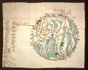
Introduction Phillip II, King of Spain decreed in May of 1577 that the Council of the Indies prepare a general survey of all the Crown’s holdings in the Americas. In response to this royal request Juan Lopez de Velasco, cosmografo-cronista mayor of the Council of the Indies, designed a fifty-question inquiry to be sent to the various Viceroys of the Americas. 1 The Viceroys, in turn, passed the questionnaire on to the corrigimientos, the local governmental administration units. The fifty question survey asked the compiler to provide information on the political geography, environment and terrain, town boundaries, languages, indigenous systems of government, historical traditions, economic life and religious institutions. Questions 6, 7, 8, 12, 16, 19, 34, 39, 41, 43 and 45, for example, ask for textual geographical information, while 42 and 47 request maps of nautical information. 2 It is Question 10 that specifically asked the respondent to "Describe the sites upon which each town is established. Is each upon a height, or low lying, or on a plain? Make a map of the layout of the town, its streets, plazas, and other features, noting monasteries, as well as can be sketched easily on paper. On it show which part of the town faces south or north." 3 The corpus of respondent information provides an invaluable primary source of knowledge for the analysis of pre-contact, as well as, early colonial indigenous cultural practice. These texts are known as Relaciones Geográficas, with the largest number of respondents coming from New Spain. The extant documents are housed in three depositories. The Archivo General de Indies in Spain holds eighty texts and twenty-two maps. The Royal Academy of History of Spain possesses forty-five documents. And the final collection of forty-one texts and thirty-five maps reside at the University of Texas, Austin in the Nettie Lee Benson Latin American Collection. 4 As a student of Latin American/Mesoamerican art history las pinturas or mapas of the Relaciones Geográficas present an interesting corpus of sixteenth century colonial Mexican painting. As Barbara Mundy points out in her study, The Mapping of New Spain, there is a marked difference in las pinturas painted by the non-indigenous artist and those executed by an indigenous hand. In her analysis of sixty-nine pinturas she finds that 45 or 65% of the works were by an indigenous artist. In her examination of the fifteen Relaciones Geográficas executed by Spaniards and Creoles she found that while the textual portion of the questionnaires was "often discursive and thorough," the maps by the non-indigenous artists were "perfunctory, awkward, almost careless," in marked contrast to the care given the text. According to Mundy, the native artists, again in marked contrast, have an expertise in both the artistic conventions of their (the indigenous) world and the western traditions. 5 Los indios, survived in a world where "both ideology and practice pulled the image to center stage." Mundy states, as the world around them changed, they were compelled to find new ways to represent it. This reflected a totally different alignment toward the iconography and the status of the image in the maps painted.
Click to download the report in PDF format: El Mapa de Teozacoalco (243 KB) The PDF files require Adobe Acrobat Reader.
For information on this report submitted 09/01/2000 contact: |
||
| Return to top of page | ||
|
Text links to all pages at this site are available at the FAMSI INDEX |
||

