|
Visualizing Maya Settlement: the Electronic Atlas meets Google™ Earth Walter R. T. Witschey and Clifford T. Brown Ver en Español. |
|
|
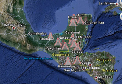
During the past decade the data acquisition and collation project "Electronic Atlas of Ancient Maya Sites 1 " has been systematically recording the coordinates of ancient Maya sites, and sites near the Maya region. Data sources include older and new maps; project reports; and field data acquired with Global Positioning units (GPS systems). Data has been standardized to a single format (WGS 1984 latitude and longitude in decimal degrees) within an MS Access database. From this dataset, the authors produce GIS systems, maps, and datasets for other researchers. This document describes a dataset (MayaSites.KMZ) created for Google™ Earth 2 located on the authors' web site http://MayaGIS.smv.org, available in the Google™ Earth Gallery. The dataset presents ~6,000 locations in a Google™ Earth file for eastern Mesoamerica. Each location plots on the map space generated by Google™ Earth as a small pyramidal icon. Sites are grouped by rank-size (rank 1, rank 2, and ranks 3-5, including small unnamed sites). The data may be used by first installing Google Earth (a free program download from Google at http://earth.google.com/). Then locate a web version of the file. The file may be accessed through the Google™ Gallery at http://tiny.cc/PHZYL or from the authors' web site at http://MayaGIS.smv.org/MayaSites.KMZ or from the FAMSI web site at http://www.famsi.org/research/MayaGIS/MayaSites.KMZ. Clicking on the file provides an option to "OPEN" or to "SAVE." The 'open' option will start Google Earth and load the data onto your view of the earth. If you choose 'save' then you can save the file to your computer, then double-click on it to open it in Google Earth, or you can start Google Earth and drag the file icon onto the view of the earth. In all cases, the MayaSites file will open a three-tiered view of Maya sites. Rank 1 sites will be visible immediately. Zooming in closer with reveal rank 2 sites. Zooming in further still will reveal rank 3, 4, and 5 sites. The description balloon for each site carries its name, where known, its rank, and the reference to the bibliography indicating the source of the location data. The point properties provide the latitude and longitude. The bibliography may be separately accessed as a PDF document at http://mayagis.smv.org/MayaSites_Bibliography.pdf. or on the FAMSI website at http://www.famsi.org/research/MayaGIS/MayaSites_Bibliography.pdf. The authors request that you feel free to provide additional data, or corrections, via email. We would also appreciate learning of your uses of the data in your own research. Further Reading For papers and present ionsns about the authors GIS work go to http://MayaGIS.smv.org. About the Authors Clifford T. Brown, Ph.D.: of Florida Atlantic University is a research fellow of the Middle American Research Institute, Tulane University. He previously was a consultant advising the U.S. Navy on archaeological issues. He holds a B.A. in Archaeology from Yale University, and an M.A. and Ph.D. in Anthropology (specializing in Maya archaeology) from Tulane University. Prior to taking his current position, he worked as an archaeologist for the U.S. Army Corps of Engineers, and before that, as an employee of a private consulting archaeology firm. He has excavated throughout Mesoamerica and the southeastern United States. Send an e-mail to Walter R. T. Witschey, Ph.D.: is Professor of Anthropology and Science Education at Longwood University, the Director Emeritus of the Science Museum of Virginia, Richmond, Virginia and a Research Fellow of the Middle American Research Institute, Tulane University. He is past President of the international Association of Science-Technology Centers and of the Virginia Academy of Science. He holds a B.A. in Physics from Princeton University, an M.B.A. in Operations Research from the University of Virginia, and an M.A. and Ph.D. in Anthropology (Maya Archaeology) from Tulane University. Prior to joining the Science Museum he served four years as a Systems Engineer (Scientific Systems) for IBM, and 15 years as CEO of a computer management and systems business he co-founded, The Computer Company. Send an e-mail to
Do you have GIS data for an Ancient Maya Site? If you are a researcher in the Maya area, we especially welcome you to supply locational and other information about newly investigated sites or high-precision GPS coordinates for verification of well known sites. Please email the following information to . A sample Excel data file can be downloaded here.
|
||
| Return to top of page | ||
|
Text links to all pages at this site are available at the FAMSI INDEX |
||