| |
The Process of Digging
This page features the processes of an Archaeological Dig. Follow the links to learn about the processes in an archaeological dig site.
 |
|
The Process of Digging |
| |
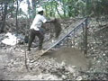
Removing the Topsoil  |
| |
Using a pick ax |
| |
A tall dry sifter |
| |
A hand-held dry sifter |
| |
A trowel |
| |
A small poker and paint brush |
| |
Wet brushing |
 |
|
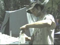
Soil Phosphate Testing |
| |
Dr. Richard Terry of BYU with the assistance of BYU students Jacob Parnell, Fabian Fernandez, and Benjamin Crozier, apply the process of phosphate prospecting and heavy metal resulting in immediate feedback to excavators about phosphate concentrations and possible midden loci in habitable sectors. Such sampling has produced great success in predicting the location of rich middens and human burials.
Also during the 1999 field season, ten soil profiles located within Piedras Negras and at rural sites outside the city were described and samples collected from each horizon. Soil properties were characterized and taxonomic designations were determined at the Soil Analysis Laboratory at Brigham Young University.
|
|
| |
Outcomes and uses of soil phosphate testing |
| |
Setting up a grid |
| |
Fabian digs a hold 2 centimeters deep |
| |
A test pit and soil horizons |
| |
The analysis process |
| |
Soil samples |
| |
Layers of soil |
| |
Explanation of a sifter |
| |
Chemicals in phosphate test |
| |
De-ionized water |
| |
The extractor |
| |
Dr. Terry's phosphate process |
| |
Jacob pours samples into filters |
| |
Diluting concentration |
| |
Concept of relative values |
| |
Blank or Control sample |
| |
The colorimeter |
| |
|
 |
|
Mapping |
| |
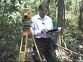
Zachary Nelson’s computer-assisted mapping established, for the first time, absolute elevations in peripheral zones. Nelson also concentrated in the southeast zone of Piedras Negras proper, known to contain many hitherto unmapped mound groups. His mapping recorded no fewer than 68 buildings,
many of them missed by Penn mappers in the 1930’s. Typically, these lay in irregular groupings in areas of dense gaymil (second growth) and on low ridges in the seasonal bajo below the South Group.
|
|
| |
Introduction to the process of discovering and mapping new structures |
| |
A brecha |
| |
The process of taking points using a Total Station |
| |
Zach describes his current location and the process of mapping |
| |
The process of 'sighting' points |
| |
The type of paper used |
| |
What can be ascertained from the survey process |
| |
Entering the data into the MC5 data collector |
| |
Zach downloads data from the MC5 collector to his laptop |
| |
Zach describes the work as the real fun of archaeology |
 |
|
Recording |
| |
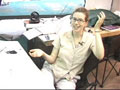
Independent architectural illustrator Heather Hurst produced architectural renderings that provided three dimensional perspective on the dig layout and individual buildings.
|
|
| |
Heather Hurst explains her illustration of the dig site |
| |
From plans and profiles to perspective |
| |
How the drawings are helpful |
| |
The use of computers in Heather's work |
 |
|
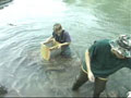
Sifting Process |
| |
During the 1999 field season, BYU student Emily Elmer floated hundreds of soil samples sent in from excavations with excellent retrieval of carbonized plant remains, fish bone, lithics, and small artifacts.
|
|
| |
Emily explains the float process |
| |
Demonstration of the first step in sifting |
| |
Ben (BYU student) removes the lite float |
| |
Explanation of the process of removing the lite float |
| |
Using a tube sifter to remove more lite float |
| |
Emily hangs the float bags out to dry |
| |
Sorting and analyzing the contents of a bag |
Previous Page | Introduction
Return to top of page |
)