| FAMSI © 2003: Stephen L. Whittington |
||
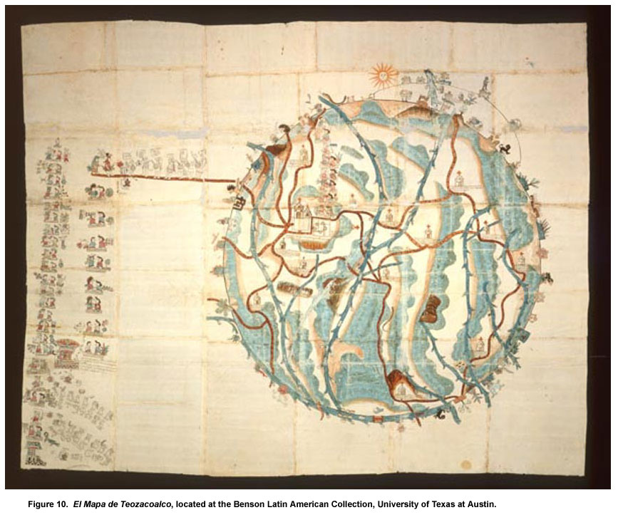
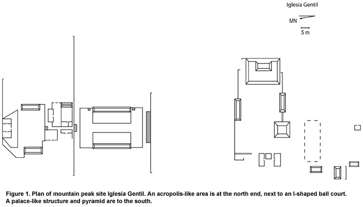
El Mapa de Teozacoalco: An Early Colonial Guide to Cultural Transformations Final Report Guided by El Mapa de Teozacoalco, an early Colonial map associated with one of a series of texts known as Relaciones Geográficas (Anders et al. 1992a, 1992b; Benson Latin American Collection 2000; Caso 1949, 1960), archaeological survey partially funded by the Foundation for the Advancement of Mesoamerican Studies, Inc., has begun to produce data related to changes in settlement characteristics associated with cultural transformations in one area of the Mixteca Alta around the town of San Pedro Teozacoalco. This work has begun to fill a 2,100 square km blank on the archaeological map. The project is one of the first applications of survey to exploration of a mapa from the Mixteca Alta. El Mapa de Teozacoalco was drawn about 1580 using conventions of both European map-making and Mixtec codex-painting. It shows natural features, human constructions, and boundary markers related to the Colonial municipality of Teozacoalco and probably also to its precursor kingdom. Pictures of churches with Spanish glosses identify towns, while Mixtec toponyms, or place glyphs, identify municipal boundary features. Because it includes detailed genealogical data for rulers of Teozacoalco corresponding to information in the Codices Nuttall and Vindobonensis, El Mapa was of central importance to Alfonso Caso’s (1949) research on Mixtec dynastic histories and writing. By the end of the 1990s, researchers (Anders et al. 1992a; Coffman 1982; Mundy 1996) had tentatively identified San Pedro Teozacoalco as the cabecera, or capital, seven of 13 estancias, or subject communities, and some geographic features defining the border of the municipality. The remaining estancias had been abandoned during the four centuries since El Mapa was drawn and knowledge of their locations had been lost to students of Mixtec culture. No archaeologists had spent significant time in the area verifying the identifications on the ground. Balkansky et al. (2000) reviewed archaeological work that had occurred in the Mixteca Alta by the end of the 1990s. Their review demonstrated an absence of work within the region covered by El Mapa de Teozacoalco south of their large Central Mixteca Alta Settlement Pattern Project Survey area. During February 2000, the late David Shoemaker and I undertook preliminary exploration of the area depicted on El Mapa (Shoemaker 2000). We visited 29 sites dating from 500 B.C. to the Colonial period and defined the northern third of the old municipality’s boundary. The survey made it clear that many other sites remained to be located and explored. During April 2002, Nancy Gonlin and I led a team that visited and recorded 35 new sites. We also revisited 12 sites from 2000. The locations of 16 sites that could not be visited because of lack of time were recorded. Archaeological surveys in 2000 and 2002 provided verification of identifications of Teozacoalco and ten estancias, and produced new data on previously unidentified settlements and border markers (Table 1). Byland and Pohl’s (1994) archaeological survey of the Tilantongo and Jaltepec regions, which revealed sites corresponding to places depicted in Mixtec codices, was the model for the project. In the process of searching for communities and features that appear on El Mapa we learned the locations of earlier sites that do not appear there. Team members traveled by pickup truck to remaining present-day towns identified as former estancias, recorded associated archaeological remains, and located abandoned estancias and natural and man-made features that define the boundary of the municipality. We contacted municipal authorities and learned the locations of sites and Mixtec and Spanish names of settlements and geographic features. In the company of guides representing the municipal authorities, we visited sites described to us and ones known from the previous season. We recorded the location of each site, determined with a GPS device, on topographic maps and INAH site registration forms. We sketched maps of sites, collected ceramic and obsidian artifacts from the ground surface, and documented each site photographically. The ceramics found on the ground during survey are related to ceramics from other parts of Oaxaca whose chronologies are well defined (Lind 1987), so we used them to determine the antiquity of sites. Patterns in the location and characteristics of sites within the survey region have begun to emerge. Many of these patterns are similar to what has been encountered in other survey regions in the Mixteca Alta. Nearly all of the sites have a Postclassic component, so temporal patterns remain difficult to identify at this time. One set of sites is on mountain peaks. Often these sites are near or overlook existing towns. They typically have monumental architecture at the highest point of the mountain, with heavily terraced slopes surrounding the peak. Iglesia Gentil is the site with the largest concentration of monumental architecture encountered to date (Figure 1). It overlooks the town of San Pedro Teozacoalco from the top of Cerro Amole, which is marked with a red cross on El Mapa. The extent of the site is 260 m x 225 m. There are more than 38 mounds, the tallest 5 m high. The major feature of the mountain top is a large I-shaped ball court. Other important constructions are an acropolis-like area at the north end of the site and a large pyramid and palace-like structure in the south area. The steep slopes of the top third of the mountain are densely covered with settlements and terraces. An ancient road runs around the mountain at the bottom of the densely settled area. Another set of sites is located on mountain ridges. These sites typically have one or more plazas surrounded by large structures and impressive, apparently defensive walls positioned at some distance from the site core (Figure 2, shown below). There are sometimes residential areas and terraces surrounding the plazas.
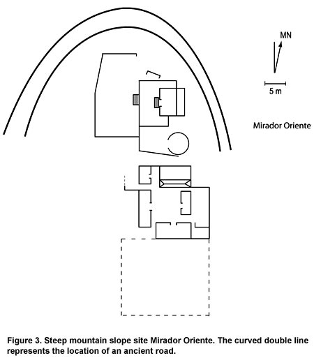
Steep mountain slope sites are on the upper slopes of Cerro Amole, are related to the large site on the peak, and include concentrations of significant architectural features (Figure 3). Between them are almost continuous areas of terraces. Gentle mountain slope sites are located around the base of Cerro Amole and other mountains. Their relationship to sites located at higher altitudes is not certain, and they may be more closely associated with sites below them. Some have relatively large mounds surrounding plazas, but others are agglomerations of structures without clear organization. Five estancias and one other settlement shown on El Mapa but lying outside of Teozacoalco’s territory are on gentle mountain slopes. The most significant gentle mountain slope site for verifying El Mapa is San Jerónimo, an abandoned estancia. This 454 m x 50 m site overlooks the modern town of Zapotitlán del Río, to which the population of San Jerónimo moved in the 19th century. The site has ruins of a church and two mounds, along with many terraces and a cistern (Figure 4, shown below). The larger, 2.5 m high mound probably was the residence of the local governor.
Hilltop sites are located on well-defined elevations within river valleys. Two of the three sites located so far have Formative period ceramics (Figure 5, shown below). Hilltop architecture at these two sites consists of only one line of foundation stones flush with the ground surface. The slopes around the hill tops are covered by extensive terracing. The third hill top site is Postclassic.
Elevated flat terrain sites are located in relatively level areas between mountain ranges on one side and river valleys on the other where extensive agricultural land is available. San Pedro Teozacoalco and some of the estancias from El Mapa that were never abandoned are elevated flat terrain sites. Two earlier sites have also been found in this terrain. Recent construction and reused ancient structures complicate defining pre-Hispanic settlement patterns in continuously-occupied towns. The foundation of the ruler’s palace shown on El Mapa still exists in the center of San Pedro Teozacoalco as a 50 cm high 28 m x 26 m mound (Figure 6, shown below). A small stairway ascends the mound at one corner. The modern church is located precisely where El Mapa shows a church adjacent to the palace. Deep sewer trenches dug around the town’s central plaza during 2002 recovered only a few artifacts, including Formative and Postclassic ceramics, and did not reveal any buried constructions. Terraces and stone walls of uncertain antiquity exist throughout the modern town.
Rolling terrain sites are located in areas of uneven topography distant from mountains. Site characteristics are diverse, and include a sherd scatter, a large single mound site, and the most extensive site found to date. The latter site extends 6.7 km from north to south and consists of hundreds of Postclassic terraces, an unknown number of stone beehive-like structures, some apparently used as kilns or ovens and others possibly inhabited, and square houses and towers (Figure 7, shown below). Closely-spaced parallel terraces running perpendicular to the slope cover expanses of the site and are interspersed with U-shaped structures. The terraces may have been used in maguey horticulture. A border toponym in the form of a labyrinth on El Mapa appears to correspond to the site.
Alluvial land sites are located directly adjacent to rivers and alluvial land. They are notably rare in the areas surveyed to date. Only one of the four sites located dates to pre-Hispanic times. The others are primarily Colonial and two appear on El Mapa. One of these is San Francisco Cahuacua, a continuously-occupied estancia. Another is the abandoned estancia of San Juan, where the stone, brick, and mortar ruins of the walls, floor, columns, and vaulted roof of a church lie in an alluvial pocket of the Río Minas (Figure 8, shown below).
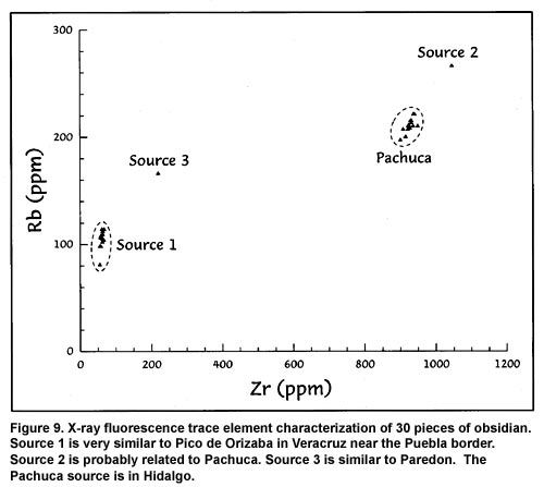
Caves used by humans exist in cliffs adjacent to rivers and in mountainsides. Most are natural, although some are of human construction. Ten to 15 gold mines are located near the abandoned estancia of San Juan on the Río Minas and probably date to the Colonial period. Finally, two petroglyphs of unknown antiquity showing animals with four legs are located high on an overhanging cliff. We submitted 30 pieces of obsidian to Northwest Research Obsidian Studies Laboratory for x-ray fluorescence trace element characterization and obsidian hydration dating. Results indicate that obsidian should be useful for obtaining relative dates within local areas and, after appropriate climatological data can be gathered in the future, for obtaining absolute dates across the entire area of El Mapa. The obsidian is from four distant sources: the Pachuca source in Hidalgo, another source (2) probably related to Pachuca, a source (1) very similar to Pico de Orizaba in Veracruz near the Puebla border, and a source (3) similar to Paredon (Figure 9). Obsidian came from multiple sources at most sites where multiple obsidian samples were tested. Once temporal control of obsidian hydration rates is established and samples from more sites are tested, the spatial distribution of obsidian from each source across the study area should help us evaluate changes in trade networks through time. We do not claim that the survey undertaken in 2000 and 2002 was either systematic or full-coverage. Rather, it was an emic survey focused on exploring and verifying an exceptional Colonial mapa, in which a Mixtec artist and a Colonial administrator apparently collaborated to produce a detailed, first-hand picture of the locations of human settlements, geographic and cultural features, and the boundaries of a municipality as they existed around 1580. Project goals were to verify the existence and location of settlements and geographic and cultural features within the territory of the municipality and to determine which geographic and cultural landmarks correspond to Mixtec toponyms and other pictures drawn around the borders of the municipality on El Mapa. We encountered rich archaeological remains of a Postclassic Mixtec kingdom and its Classic and Formative antecedents while pursuing these goals. We plan to return to the field in November to verify the locations of the remaining estancias and boundary features. We will also visit 16 known pre-Hispanic sites. We anticipate that municipal authorities will identify and lead us to additional pre-Hispanic sites of which we currently have no knowledge. In coming years we intend to request permission to test-pit a selection of known sites to determine if they are single or multiple component sites. This will also allow us to determine the antiquity of some important sites where ground cover was too heavy to recover reasonably large samples of ceramics during survey. Eventually we hope to undertake both a full-coverage survey modeled on the neighboring Central Mixteca Alta Settlement Pattern Project and extensive excavations at the large mountaintop site above San Pedro Teozacoalco. Our archaeological project based on El Mapa de Teozacoalco most obviously has potential to provide insights into the Postclassic-Colonial cultural transition. We can already see that Spanish administrators apparently placed Colonial settlements in carefully selected locations, either on top of or adjacent to Postclassic Mixtec settlements with access to expanses of raised or alluvial agricultural land and water. Many Postclassic settlements seem to have been abandoned, probably because of population concentration for administrative purposes, depopulation due to the effects of European infectious diseases, or both. Settlements we opportunistically encounter in exploring the area of El Mapa have potential to provide insights into earlier cultural transitions by revealing the changing importance of defensive locations and constructions, the concentration and dispersal of population, and the expansion and contraction of trade networks. The insights about cultural transitions provided by this project will not necessarily be new or unique to the area of El Mapa, but they will relate to insights coming from other areas and will help to provide a more complete picture of the history and prehistory of the Mixteca Alta and Mesoamerica as a whole. |
||
|
Text links to all pages at this site are available at the FAMSI INDEX |
||


