|
John Pohl's MESOAMERICA |
|
|
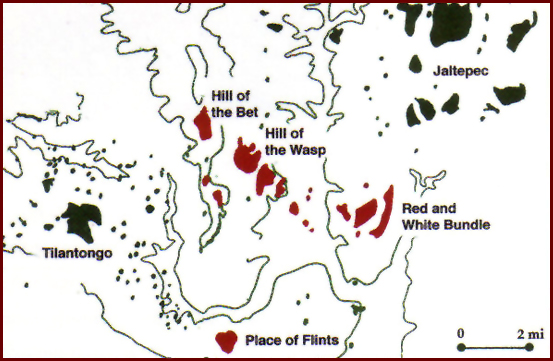
ANCIENT BOOKS: Mixtec Group Codices CODEX SELDEN/CODEX AÑUTE Place Signs Many Mixtec pictographs are composed with specific usages of the Mixtec language in mind. Nowhere is this more evident than in the composition of place signs. Mexican archaeologist Alfonso Caso was the first to establish Mixtec manuscript studies as a special field in Mesoamerican research. He was stimulated by his discovery of artifacts buried in Tomb 7 of Monte Albán that were iconographically and stylistically related to the codices. He embarked on an intensive study of not only the eight principal screenfolds, but numerous Post Conquest lienzos and maps as well. To date, Caso's 1949 breakthrough in Mixtec Studies remains unparalleled. His article (written in 1949) explains the 1580 map that accompanied the Relación Geográfica of Teozacoalco, a town in the Mixteca Alta. The map contained a glyphic configuration that also appears with some frequency in the codices. It is a black frieze surmounted by a temple with a band of "star/eyes" in the roof ("ñuu" means both "eye" and "star" in Mixtec). It is glossed as "Tilanton" (Tilantongo or "Little Black Place" in Nahuatl), refering to a remote town in the Mixteca Alta. Caso knew that the Relación de Tilantongo, a Colonial report to Phillip II of Spain, gave Tilantongo’s full name as "ñotoo-huaidadehuj" a corruption of "ñuu tnoo huahi andehui" meaning "Black Town, House of Heaven". Mary Elizabeth Smith (who studied with Caso) began her analysis of place signs with Codex Colombino, which she attributed to the south coast of Oaxaca, and proposed that Lord Eight Deer spent much of his early life at the kingdom of Tututepec. In making her identifications, Smith relied heavily not only on Colonial documents, but on extensive field research as well. She recorded many of the names for present-day towns and archaeological sites still known in the Mixtec language today. Smith's book "Picture Writing from Ancient Southern Mexico: Mixtec Place Signs and Maps" stands as the ground-breaking treatise on place sign decipherment (Smith 1973a). Mixtec place signs are composed of two parts, a geographical "substantive" and one or more "qualifiers". The qualifying elements are numerous. They can refer to colors and sizes of things, gods, numerals, calendrical signs, animals, plants, weapons, people… virtually anything. The geographical substantives are fewer in number and they always represent some landscape feature either natural or man-made. Smith identified four principal substantives representing towns, hills, fields or plains, and rivers. In addition there are another six substantives that represent ballcourts, temple or house platforms, wells or springs, lakes, rocks or cliffs, and markets. Further complicating their system is that the Mixtec also used modifiers for the substantives that meant "at the foot of", "at the top of" and so forth, often using signs for parts of the human body. In emphasizing a study of place signs, Smith has not only been able to identify the location of the activities of successive kings and queens, but coincidentally to also identify patterns of interaction between those rulers' territories. We know that the people depicted in the manuscripts are members of royal lineages ["linajes" in Burgoa's terminology] who maintained preferred marriage patterns between their territories through time. Evidence for marriage patterns allows an archaeologist to presume that certain sites might display some sort of shared artifactual similarity, particularly in ceramic style. Consequently, studies of interaction patterns involving place signs, together with archaeological studies of artifactual relationships between sites, can be used comparatively to reconstruct social interaction from two distinct anthropological views. Smith's identification of Codex Selden as a manuscript from the Nochixtlán Valley is a good case in point (Smith 1983a). Smith compared the glyph for what Caso had called "Belching Mountain", found in Codices Bodley and Selden, with Colonial and modern names for the town of Magdalena Jaltepec (Jaltepec means "Hill of Sand" in Nahuatl). The Mixtec place sign as it appears in Codex Selden is often composed of a hill-substantive to which two principal qualifying elements have been added. These are a human mouth and a blob of "sand". The mouth represents the term "a" in Mixtec or "place" where something exists. The sand element stands for "ñute". In the Mixtec language, Magdalena Jaltepec’s name is Añute, or "Place of Sand". In identifying the place sign of Jaltepec, Smith had also located the activities of Lord Eight Deer’s rival, Lady Six Monkey. Jaltepec is still a prosperous town located on Tilantongo’s eastern border at the southern end of the Nochixtlán Valley. Between 1985 and 1989 Bruce Byland and I were able to identify not only the House of Heaven and the royal palace of Eight Deer at Tilantongo, but also the royal palace of Lady Six Monkey.
Place Signs identified: Ravine of the Head, Yute Coo. Apoala Achiutla, Zahuatlán, Chindua, Sachio, Hill of the Head, Andua, Place of the Head, Teozaocalco, Jaltepec, Tilantongo, Chalcatongo, Red and White Bundle, Place of Flints, Etlatongo, Tlaxiaco, Comaltepec, H/Guaxiloltitlán, Suchixtlán. |
||
|
Text links to all pages at this site are available at the FAMSI INDEX |
||