| FAMSI © 2005: Patricia Plunket and Gabriela Uruñuela |
||
|
Dating Cholula, México
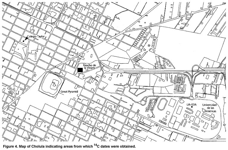
Methodology The funding provided by FAMSI was specifically used to pay for a suite of 16 14C dates from Cholula (Figure 4, shown above). Ten AMS dates were derived from samples obtained from distinct layers of fill associated with the initial construction phases of the Cholula Pyramid (as part of the Tetimpa Project), while another three determinations came from the fill of two adobe platforms uncovered during test excavations in a field adjacent to the northeast corner of the Pyramid complex, just to the northeast of the platform known as the Edificio Rojo (Noguera 1956) (as part of the Sondeo Arqueológico Rancho de la Virgen 2002). Additionally, stratigraphic excavations on the north side of the main plaza of San Pedro Cholula (as part of the Sondeo Arqueológico Colegio Coley B. Taylor 2002), in an open space on the east side of the Casa del Caballero Aguila (now the Museo de la Ciudad de Cholula), provided us with two carbon samples associated with Early Postclassic ceramics. A final date came from charcoal recovered from a Formative bell-shaped pit on the Universidad de las Américas campus, which is located on the eastern side of modern Cholula (as part of the Rescate Arqueológico UA-03A). All samples were exported with the permission of the Consejo de Arqueología of the Instituto Nacional de Antropología e Historia, and processed by Beta Analytic in Miami, Florida. In order to make better sense of the dates from the Great Pyramid, as part of the Tetimpa Project, Amparo Robles is currently making a 3D computer map with a total station of the initial construction phases for her licenciatura thesis. All dating samples have been located on this map. She has also undertaken a detailed description of the fill visible in the tunnel walls in order to better relate the dates to the building sequence. These descriptions will be a useful interpretive tool as we try to understand the development of the Great Pyramid. This is a work in progress: to date, over 1500 m have been mapped and 240 m have been recorded and described. |
||
|
Text links to all pages at this site are available at the FAMSI INDEX |
||