| FAMSI © 2005: Patricia Plunket and Gabriela Uruñuela |
||||||||||||||||||||||||||||||||||||||||||||||||||||||||||||||||||||||||||||||||||||||||||||||||||||||||||||||||||||||||||||||||||||||||||||||||||||||||||||||||||||||||||||||||
|
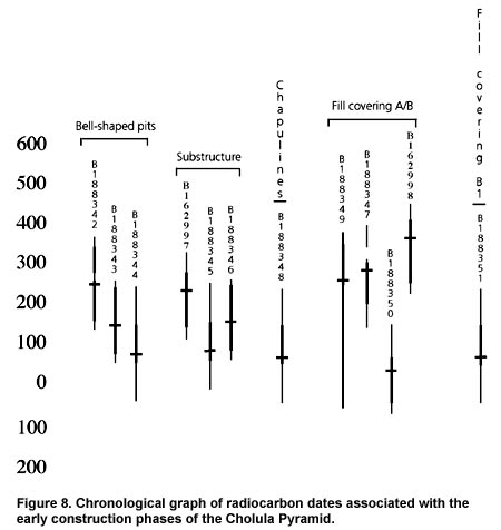
Dating Cholula, México Discussion of Results The mapping and description of the fill visible in the tunnel profiles shows that the stepped platform Marquina identified as the initial structure (Structure I, phase A) is actually the second building stage of the Great Pyramid. An unrecorded irregular pit excavated into the occupation surface on the west side of the Pyramid, in front of the central staircase of Structure I-A, penetrates to a depth of about 2 m; the east wall of this pit was then excavated to create a tunnel that perforates beneath Structure I-A approximately 53 m until it terminates in a an adobe cell ("cajón") that forms part of an earlier two-tiered platform (Structure Sub-I-A) (see McCafferty 2001 for a different interpretation). This tunnel was obviously not excavated by Marquina’s team since it is not recorded on any of his plans, nor does it conform to his very exacting standards. However, it cuts through Structure Sub-I-A–the remains of an earlier unsurfaced platform constructed of an adobe grid filled with crushed tepetate and occasional trash lenses–which rests directly on sterile subsoil (tepetate). The location of this initial construction phase and its precise relation to the later construction stages of the pyramid will appear on the computer map. We have three AMS dates from the adobe fill of Structure Sub-I-A, which indicate that it was erected sometime between the first and third centuries A.D. The 2 Sigma range of these radiometric determinations is as follows: B-162997 [cal A.D. 110 to 330], B-188345 [cal 5 B.C. to A.D. 230], and B-188346 [cal A.D. 60 to 260].
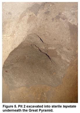
Further evidence for dating this early structure comes from six bell-shaped pits excavated into the sterile tepetate and exposed in the walls of the unrecorded tunnel beneath the phase A construction (Figure 5, shown above). Two carbonized beans and an unidentified seed from these features provided three AMS dates: B-188342 [cal A.D. 115 to 385], B-188343 [cal A.D. 45 to 250], and B-188344 [cal 30 B.C. to A.D. 225]. It would appear that the pits probably were filled between A.D. 100 and 200 as part of a resurfacing program related to preparations for the construction of the first stage of the Great Pyramid. Taken together with three dates from inside the reticulated adobe cells of Structure Sub-A (B-162997, B-188345 and B-188346), we can tentatively suggest that this first construction phase was undertaken during the second century A.D. (Table 1 and Table 2). It is important to note here that other monumental architecture in Cholula also has been dated to this time period. Excavations at the Franciscan monastery of San Gabriel on the east side of the main square of the modern city uncovered the well-preserved staircase–over 12 m wide with more than 13 steps–of a large east-facing platform that continues under the kitchen of the sixteenth-century building and the adjoining school yard. This platform also was constructed on sterile subsoil. A 14C determination on charcoal from a hearth associated with the superstructure of this platform provided a date of 1890 ± 80 BP (I-17,627) with a 2 Sigma range of cal B.C. 41 to A.D. 268 and cal A.D. 273 to 336 (Plunket and Uruñuela 2002), placing this construction in the second and third centuries A.D. Marquina (1981:121) considered that Structure I (which covers Structure Sub-I-A) belonged to the Teotihuacán I period, or Tzacualli phase (A.D. 1-150). This building consists of two stages. He indicates that stage A is an undecorated stepped platform that faces west and is divided into two groups: a basal series of five levels that is crowned by an additional set of two upper levels. Stage B corresponds to certain modifications and enlargements of the north side of the stage A structure, where talud-tablero profiles were added to the upper two levels; he assures us that the addition of the talud-tablero profile distinguishes phase A from phase B. These tableros are painted with the Chapulines Murals. From Marquina’s description, it would appear that stage B was also characterized by a new ideological program encapsulated in the mural art that accompanied the reorientation of the building from the west to the north. The decorated tableros are located on the north side of the building and wrap around the east and west corners. At the center of the north side, the talud-tablero façade is interrupted by a void which must have held a staircase although none is present. Marquina associated this architectural change in the Great Pyramid with the Teotihuacán II period (Miccaotli phase, A.D. 150 to 200) because of certain similarities between this building and the Feathered-Serpent Temple at Teotihuacán (i.e., the decorated tableros), although there is no emphasis on the northern direction in that building. The change in the orientation of the façade between phases A and B is puzzling since it only affects the upper two levels of the structure that bear the mural art. We are currently trying to understand exactly what evidence Marquina used to suggest that the talud-tablero profile was added to the existing phase A structure, but we have yet to find any. Indeed, the alfardas of the staircase that rises on the west side of the stage A structure were put in place after the painted tableros were finished. This seems to indicate that stages A and B were part of the same building program, but we have not finished our evaluation of the structural details visible in the tunnels and prefer not to make any definitive statements yet. We have no dates from the fill inside the phase A structure of the Pyramid since none of Marquina’s tunnels penetrated this building. However, the two dates that were obtained on materials recovered from the fill covering the west side of phase A near the central staircase (B-162998 [cal A.D. 220 to 450] and B-188347 [cal A.D. 95 to 265 and cal A.D. 290 to 325]) suggest that a new version of the monument (Structure II) was built between the third and fifth century A.D. (Table 1 and Table 2). A small amount of charred material was recovered from between the clay plaster and stone body of one of the tableros of the phase B construction. This provided a date with a 2 Sigma range of cal B.C. 40 to A.D. 215 (B-188348). This early date may indicate that phase B was added shortly after the completion of phase A, or that as we have already suggested, stages A and B are actually part of the same building, but it also could result from earlier carbon being incorporated into the building. This is a distinct possibility considering that there are Terminal Formative structures in the vicinity of the Great Pyramid. Additionally, we recovered two dates (AMS) from charred materials in the fill deposited on top of the north façade of Structure I-B. The 2 Sigma range is between cal A.D. 155 to 390 (B-188349) and cal B.C. 80 to A.D. 120 (B-198350). This second date is very early and probably results from incorporating older materials into the fill used to cover the phase B structure, while the first date (B-188349) may signal new building activity at the Great Pyramid in the third or fourth century A.D. It is consistent with the dates from the fill on the west side of the pyramid that provided determinations of A.D. 220 to 450 (B-162998) and cal A.D. 95 to 265 and cal A.D. 290 to 325 (B-188347) (Table 2). Taken together, these dates allow us to suggest that Structure I (phases A and B) was covered over with an entirely new building program (Structure II, the "stepped" pyramid) between the third and fifth century A.D.
Marquina (1970a:39) mentions that the north façade of Structure I-B underwent further episodes of modification and enlargement although he provides few details. In her survey of the tunnel walls, Amparo Robles found that there is another talud-tablero façade on the north side that was sliced by the tunnels in the fill that covers Structure I-B, and we have designated this as Structure I-B1. We recovered a small sample of charred material from the fill placed on top of this additional talud-tablero profile, which provided an AMS date with a 2 Sigma range of cal 40 B.C. to A.D. 215 (B-188351). Although this result might indicate that structures I-A, I-B, and I-B1 were built in rapid succession, we think it is more likely that the Pyramid’s architects commonly mined middens from surrounding areas for fill. Significantly, the date does not conflict with our suggestion that Structure I was covered over with an entirely new building (Structure II) perhaps as early as the third or as late as the fifth century A.D.
The dates we obtained from the early structures of the Great Pyramid are fairly consistent even though they come from fill, which is not the best context for dating purposes. Taken as a whole, however, the suite of 12 radiocarbon dates (Table 1 and Table 2) documents intense building activity with continuous design modifications in the ceremonial heart of Cholula during the second and third centuries A.D. This construction was initiated after the volcanic eruption that destroyed the village of Tetimpa, a fact that requires us to reconsider the motivation behind the massive building programs that characterize the Classic period at Cholula.
In a large open field known as Rancho de la Virgen, located to the northeast of the Edificio Rojo that rises at the northeast corner of the Great Pyramid, the Coordinación de Apoyo Arqueológico of the Universidad de las Américas, Puebla, undertook test excavations in 2002 (López et al. 2002a and b). Four adobe platforms were recorded 1.80 to 3.60 meters below the surface in the test pits. We recovered two samples of charred material from the two superimposed adobe platforms in Pit 5, while more organic material came from a water well excavated into the surface of another adobe platform located in Pit 6. All of these dates have 2 Sigma ranges that indicate activity in the Late and Terminal Formative, spanning the second century B.C. through the middle of the third century A.D. Noguera (1956) reported significant amounts of Late Formative material from his excavations at the Edificio Rojo. It would appear then that the area to the north of the Great Pyramid witnessed an important occupation during this time period. However, most of the ceramics associated with the surface of these platforms are from the Early Classic, when the Teotihuacán Tlamimilolpa styles were important and significant amounts of Thin Orange were in use (Figure 9, shown below).
The three calibrated dates from the test excavations span a period between 195 B.C. and A.D. 250. The Sub-I-A platform at the core of the Great Pyramid was built in the second half of this period, as were phases I-A, I-B, and I-B1. The fill placed over this building sequence doubtless contains trash generated by the inhabitants of the Rancho de la Virgen; and it is also likely that the façades of the adobe platforms in this low-lying, swampy area were mined for stone since we found little evidence of stone platform surfaces even though these were commonly used in western Puebla during the Formative and Classic (Mountjoy and Peterson 1973; Plunket and Uruñuela 1998a).
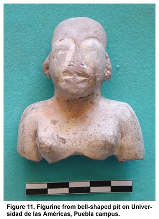
The Classic occupation is sealed by an airfall deposit of angular volcanic sand that appears to correspond to an important eruption of the Popocatépetl volcano that took place between A.D. 700 and 850 (Panfil 1996; Siebe 1996). The Postclassic inhabitants of Cholula built new houses directly on top of this sandy layer, and in general it can be used to divide the Classic and Postclassic in the area. Construction work on the north side of the Universidad de las Américas, Puebla campus uncovered six bell-shaped pits and a circular oven excavated into sterile tepetate (López et al. 2004b). These features contained ceramic materials similar to those recovered in 1969 and 1970 by Mountjoy and Peterson (1973:13-19, 46-56). The pits are in an area of thin soils, generally between 0.40 and 0.50 m, that borders a swampy drainage system filled with thick black clay. Mountjoy and Peterson (1973:13) found Middle Formative materials along the edge of this swamp, about 150 meters north of the bell-shaped pits we excavated in 2003. Although these pits undoubtedly form part of one or more Middle Formative residences along the shores of the swamp, structural elements have been damaged or destroyed by plowing and construction activities, and all that remains are materials contained in pits excavated into the sterile subsoil. The ceramics recovered from these bell-shaped pits are the earliest with archaeological provenience for Cholula, and they extend the occupation of the area back to the beginning of the Middle Formative (Figure 10, shown below, and Figure 11). A sample of charred material recovered from one of these features (Feature 1) provided a radiocarbon date with a 2 Sigma range of cal B.C. 1260 to 795 and an intercept at cal B.C. 930 (Beta 188355), the earliest dated material recorded for Cholula (Table 4).
Mountjoy and Peterson (1973:62) obtained a 14C date on partially carbonized wood associated with Middle Formative ceramics and figurines from the lower levels of the swamp clay. The sample (GX-2256) yielded a determination of 2645 ± 110 radiocarbon years or a non-calibrated date of 695 ± 110 B.C. By running this sample through the Radiocarbon Calibration Program Rev 4.3 (Struiver and Reimer 1993), we obtained an intercept of cal 804 B.C. This date overlaps with the one from the bell-shaped pit, and helps confirm the Middle Formative occupation along the south shore of the Cholula swamp.
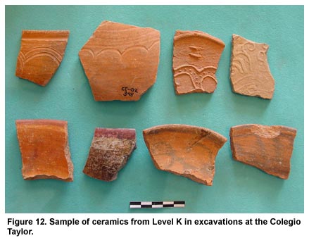
In May and June of 2002, the Coordinación de Apoyo Arqueológico of the Universidad de las Américas, Puebla, undertook test excavations in a plot of land in the middle of the block that borders the north side of the main square of San Pedro Cholula (López et al. 2002b, 2004a). Although a complex sequence of modern and colonial construction was documented in the 12×2 meter east-west exploratory trench, no remains of prehispanic buildings were located in this excavation. The post-Conquest building activity rests upon about 2.50 meters of interdigitated clays and sands. The lower part of these strata consists of dark clays that contain Late Classic ceramics, deposited directly on the sterile tepetate. These clays are sealed by a 0.20 to 0.30 meter layer of volcanic ash. On top of this ash, Postclassic ceramics, like Cocoyotla Black-on-Orange, which is similar to Aztec I, occur for the first time (Figure 12, shown below). The two dates we obtained from this excavation come from two different strata of waterlain sediments deposited above the volcanic ash.
|
||||||||||||||||||||||||||||||||||||||||||||||||||||||||||||||||||||||||||||||||||||||||||||||||||||||||||||||||||||||||||||||||||||||||||||||||||||||||||||||||||||||||||||||||
|
Text links to all pages at this site are available at the FAMSI INDEX |
||||||||||||||||||||||||||||||||||||||||||||||||||||||||||||||||||||||||||||||||||||||||||||||||||||||||||||||||||||||||||||||||||||||||||||||||||||||||||||||||||||||||||||||||