| FAMSI © 2004: Marcello A. Canuto and Ellen E. Bell |
||
|
Classic Maya Borders and Frontiers: Excavations at El Paraíso, Copán, Honduras, 2003 Season
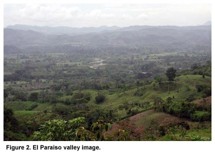
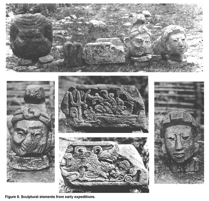
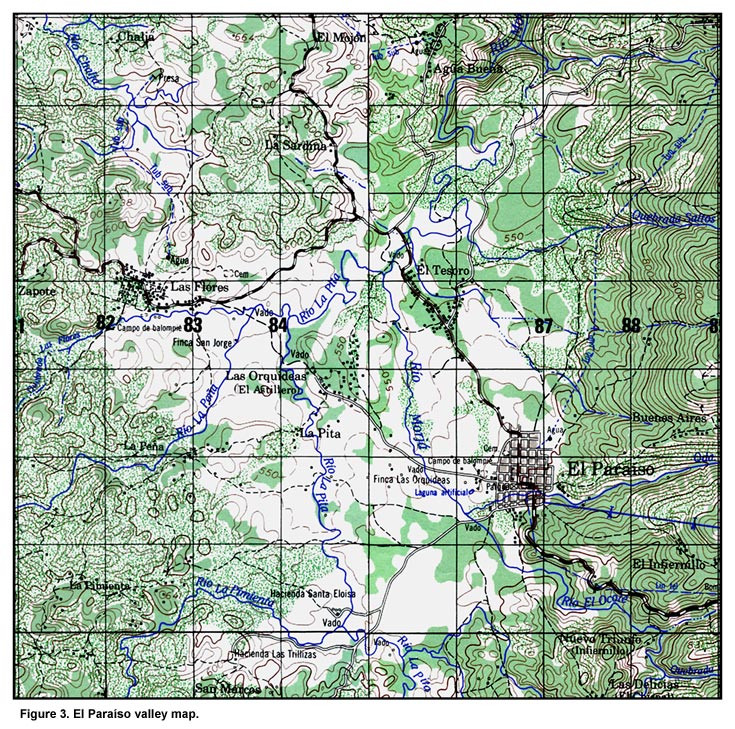
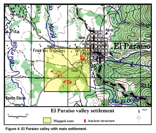
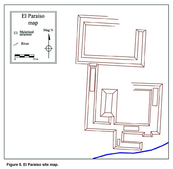
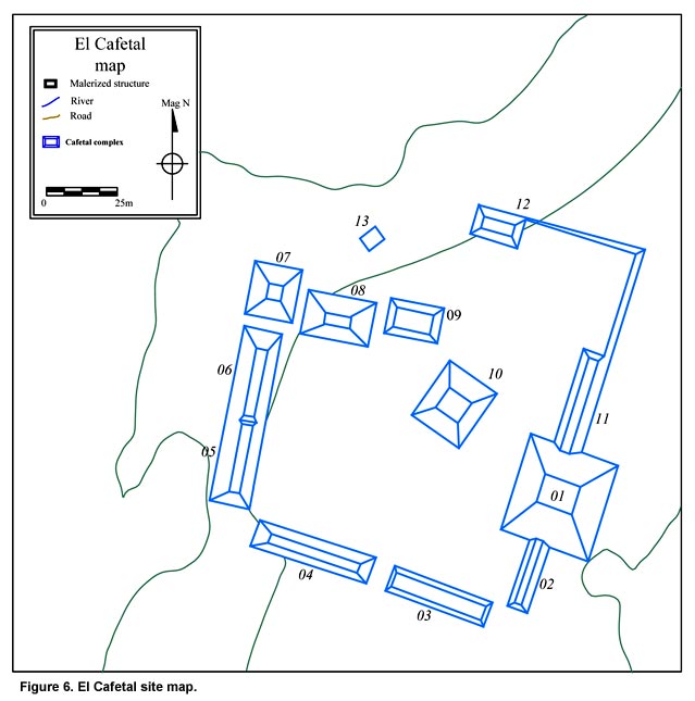
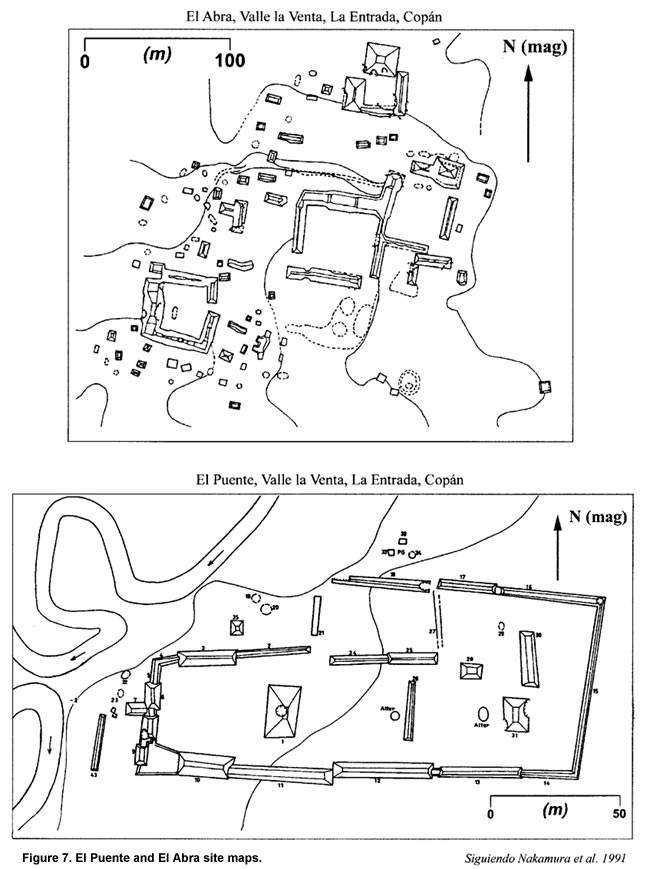
El Paraíso Valley: Relevance and Research History To address this topic, a program of archaeological research was proposed for the valley of El Paraíso, Honduras. This valley within the southeastern Maya area is centrally located among the Classic Maya centers of Copán and Quiriguá and non-Maya settlements in the Chamelecón valley (Figure 2, shown above). Situated within the "cultural interstices" of this area, the residents of the El Paraíso valley were compelled to confront these frontier differences and respond to them in some way–complying, adopting, refusing, or absorbing this heterogeneity. Consequently, the archaeological investigation of this particular area represents a unique opportunity to study the relationship between the development and maintenance of distinct (cultural) identities and polity integration. To this end, this study focuses on the following contexts of descending scalar rank: (1.) the interregional interaction of Maya with non-Maya people, (2.) the regional political economy of inter-polity elite exchanges, (3.) the local organization of intra-polity relations, and (4.) the socio-economic networks within centers. El Paraíso is located in a large, fertile valley (of the same name) within the Sierra del Espiritú Santo range, only 27 km northeast of Copán, 30 km south of Quiriguá, and 20 km west of El Puente (Figure 3). This valley was carved out by the Morjá River which flows northward into the Motagua River and is separated from the Copán and Chamelecón river valleys by low, passable ranges. It contains alluvial bottomlands more extensive than those of the nearby Copán and Río Amarillo valleys and exhibits a broad range of ecological variation (Fash 1983). Furthermore, an elevation of 600-650 masl and high levels of precipitation make double-cropping possible in some sectors of the valley. The valley contains two distinct Classic period (A.D. 400-850) centers in close proximity (Figure 4). The first, known simply as El Paraíso, is located along the southeastern edge of the modern town near the Quebrada Rosario (Figure 5). El Paraíso exhibits a quadrangular court architectural plan with an elevated platform divided into three sunken patios and Maya-style sculpture. The other center, El Cafetal, is located 1 km to the southwest on the opposite side of the Ocote River (Figure 6). Since the final occupation phase of both centers dates to the Late Classic period (A.D. 600-900), it is possible that variations in the spatial plan and architectural style of each reflect differences in the identity of their residents. In fact, these differences are repeated to the east in the La Florida valley along the Chamelecón River where El Cafetal’s open arrangement of structures around a plaza is similar to that of El Puente (Nakamura et al. 1991) and where El Paraíso’s closed court-like pattern is equivalent to that of El Abra (Figure 7). Furthermore, the topographic, hydrological, and climatological conditions of this region suggest that the El Paraíso valley was a gateway for interregional trade. In this region, all material (and ideational) goods moved along specific routes, many of which ran directly through the valley of El Paraíso. It is possible, therefore, that the residents of the El Paraíso valley acted as regional intermediaries. Furthermore, the architectural differences of its two major Classic period centers suggest the existence of different peoples, factions, or interests within the valley. In other words, as a crossroads, the El Paraíso valley straddles the context in which potential ethnic, ideological, political, and socio-economic confrontations and negotiations occurred on a daily basis. History of Research at El Paraíso Peabody and other early explorations Although sites in the El Paraíso valley have been known for over a century, almost no formal research had been undertaken there until recently. However, the valley was visited a handful of times in the first half of this century by explorers and investigators. In 1895, the German geographer Karl Sapper visited the area and produced the first map of the site located near the modern town. He called this the "El Paraíso" site (Sapper 1897). After investigations at Copán began in the late 1890s, a few explorers and researchers traveled to the El Paraíso valley. In 1914, Sylvanus G. Morley (1917, 1920) recorded sculpture at the same site (Figure 8) and three years later, in 1917, a team from the Peabody Museum Expedition, including S.K. Lothrop, made a photographic record of the site (Lothrop 1926). Finally, in 1935, Jens Yde visited the site and published a description of the same sculptures encountered by Morley (Yde 1936, 1938).
Following these visits, the valley was virtually ignored until another program of study initiated in Copán (PAC I) brought Kurt Long and William L. Fash to El Paraíso in 1979. This team discovered, mapped, and began excavations in the other large Late Classic period center of the valley located 1.5 km southwest of El Paraíso. They called this site "El Cafetal." As they encountered difficulties with local landowners, they were forced to terminate excavations prematurely and leave (Fash 1983; Long 1979; Vlcek and Fash 1986). Only recently, in 2000, has the valley again come under investigation. A team headed by Lic. Oscar Neill (IHAH) made a preliminary map of the El Paraíso site and consolidated standing architecture that had been exposed by a local resident during the construction of a private home. Also in 2000, Ellen E. Bell, Marcello A. Canuto, and Jorge H. Ramos visited the site to evaluate the feasibility of future investigations and to complete an informal reconnaissance and photographic record of both centers.
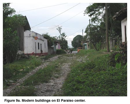
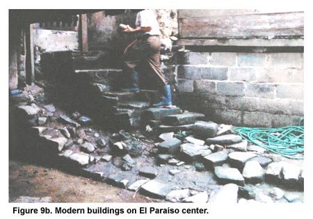
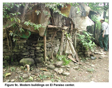
The modern town of El Paraíso has grown significantly in the last decades, slowly burying and destroying the Classic period Maya site. By 2002, the entire El Paraíso site had been covered by modern houses and gardens (Figures 9a through 9d), and the largest structure now rises only 7 m above the patio surface. Moreover, portions of the site have been flooded, mined for materials, bulldozed, and looted. Without immediate intervention, made possible by FAMSI support, the destruction of this important center would have most likely accelerated.
While the damage is significant, a great deal remains to be investigated, including standing architecture around the smaller of the two plazas. Furthermore, test excavations conducted in 2002 (Canuto et al. 2002a) indicate that subsurface deposits remain intact and that extensive archaeological excavation will yield a wealth of information, generating the local interest necessary to ensure the site’s preservation.
Meanwhile, the sites outside of the modern town have remained almost completely unknown to the local residents and are, therefore, in a much better state of preservation. While many of the smaller sites appear to have suffered extensive plough and tractor damage, the bigger sites–like El Cafetal–have proven too large and rock-filled to be leveled. | ||
|
Text links to all pages at this site are available at the FAMSI INDEX |
||
