| FAMSI © 2004: Marcello A. Canuto and Ellen E. Bell |
||
|
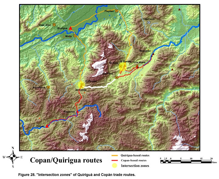
Classic Maya Borders and Frontiers: Excavations at El Paraíso, Copán, Honduras, 2003 Season Conclusions It seems clear that spatial plan, architectural style, and decoration represent important markers in this region (Schortman and Nakamura 1991). It appears as if there are two distinct architectural and spatial aesthetics within this area. One is represented by the QP3 type composed of four platforms forming a quadrangular court/patio space with sealed corners and restricted access. This type was common in the Lower Motagua valley (Ashmore 1981; Schortman 1991) and around Quiriguá. This type is also located in the El Paraíso, La Florida, La Venta, and even Quimistán valleys at sites like Morjá, Playitas, Quebradas, El Paraíso, Las Pilas, and El Abra. The second type seems to originate in central Honduras and is represented by a looser arrangement of both range and pyramidal structures forming a large plaza space with multiple access points. This type varies in size and monumentality but can be seen at sites like La Sierra, El Coyote, Roncador, Los Higos, El Puente, and El Cafetal (it is possible that Río Amarillo was initially constructed after this pattern). At the moment, the social, economic, political, or even ethnic salience of these architectural, spatial, and decorative differences remains a matter of speculation. It is clear, however, that both traditions were increasingly influenced by an overlay of a complex of elite Maya traits. Interestingly, this complex of traits is rather consistent throughout the region, consisting of cut-stone masonry, stucco floors, plastered façades, architectural sculpture, hieroglyphic texts, and access to a slew of exotic worked goods (jade, shell, fine ware ceramics). This overlay has traditionally been crassly interpreted as a form of "Mayanization" by Copán’s rulers of their non-Maya neighbors. In recent studies (Manahan and Canuto n.d.; Schortman and Nakamura 1991; Schortman, Urban, and Ausec 2003), interpretation has shifted focus to the processes of regional interaction. This approach has shown how regional elites manipulated and traded on different identities situationally, forming and dissolving alliances in accordance with their local interests. The motivations and practices of regional elites can account for the diffusion of elite Late Classic Maya traits throughout the region without their concomitant "mayanization". In other words, it cautions against knee-jerk reliance on normative ethnic "tags" by focusing on the materialization of elite interactions and strategies. Given this approach, the late Coner mayanization of hinterland centers might be more related to the political fission that occurred in A.D. 738 between Copán and Quiriguá than with the (inexorable) enculturation of non-Maya peoples. Seen in this theoretical paradigm, the Copán-Quiriguá conflict likely cleaved the region into at least two political factions (elite groups) with mutually exclusive and competing interests. It is within this factional and fractured political landscape that the process of "Mayanization" should be understood. For PAREP’s research, an obvious point of departure would be the unexplained proximity and contemporaneity of El Cafetal and El Paraíso. This spatial and temporal coincidence greatly complicates the interpretation of both centers vis-à-vis not just each other, but also the rest of the region. However, this "dual center" scenario is not unique to this region. In the La Florida valley, the centers of El Abra and El Puente seem to mirror the El Paraíso and El Cafetal relationship and are less than 2 km apart from each other also. As mentioned above, El Cafetal and El Puente reflect a similar aesthetic, while El Paraíso and El Abra share many attributes. In the case of both pairs of centers, one center derives from a different cultural tradition than the other, even though the rulers of all these centers had sought some engagement with and adoption of the Late Classic Maya elite culture (that is, all these centers demonstrate some overall of elite Maya traits). Despite variations in how these rulers were incorporated into the region’s Maya elite culture, these centers inescapably reflect "primordial" (spatial, architectural, and aesthetic) differences among one another that reinforce the notion of this region’s multi-ethnic composition. The two instances of this "dual-center scenario" is rendered more interesting by the fact that the two pairs of centers are located in critical intersection zones–that is, where the regional interests of both Quiriguá and Copán overlapped (Figure 28). To access central Honduras goods, Quiriguá-based traders would have been constrained to traverse through the Chamelecón drainage. From Quiriguá, the routes leading south to the Chamelecón would have terminated in the El Paraíso and La Florida valleys. Importantly, the routes that gave Copán-based traders access to both central Honduras and the Caribbean coast also traversed through these same two valleys. Since these routes to the Chamelecón intersect, the rulers from both polities undoubtedly fretted over safe passage of their goods in these two valleys. Perhaps as a strategy to safe-guard their interests, the rulers from both polities offered access to higher status and authority to the leaders of select hinterland centers, thereby creating a political frontier in an area already cleaved by ethnic differences. The chronological sequence of Late Classic events occurring in the El Paraíso valley are consistent with this model. The rapid development of El Paraíso as a Maya-style elite center during the latter half of the 8th century A.D. roughly coincided with equally transformative construction and architectural embellishment at Río Amarillo. Even Los Higos and perhaps other centers in the La Venta and Florida valleys also achieved their maximum size during the late Coner phase. These coincidental events suggest that the political and economic events between Copán and Quiriguá in the mid-8th century A.D. had a regional impact. These hinterland architectural developments might even have analogs within the Copán valley itself. During the reigns of Copán’s last two rulers, several elite residential compounds throughout the Copán valley (9N-82, 9M-146, and 8N-11) were renovated and graced with hieroglyphic benches. This chronologically coincidental development has been interpreted as an example of either the disintegration of the ruler’s monopoly control over certain dynastic privileges and symbols (Fash 2002), or the revitalization of centralized authority through the imposition of a dynastic imprimatur (Plank 2003). In either case, these interpretations could easily apply to the whole region including the hinterland centers. If the developments at the elite residential groups in Copán and the hinterland centers result from some of the same motivations and processes, then models of polity organization and collapse at Copán will necessarily have to be combined with models of interregional interaction. Furthermore, these models will have to be applied to a context within which major cultural differences within the region could have led to processes of ethnogenesis. This preliminary research has led to a host of new questions that will prove central to future research. Thanks to the funds provided so generously by FAMSI, the initial general interest in this little-known valley north of Copán has developed into a series of clearly defined research questions that also retain a broad scope and a potential to impact regional models of polity maintenance, regional interaction, and identity formation. Specifically, we can now posit the following questions: (1.) Are the different spatial aesthetics of the hinterland centers the materializations of distinct local identities resulting from a dynamic program of ethnogenesis? (2.) How are the various instances of "Mayanization" related to elite strategies relating to political affiliation? (3.) Were the processes of regional ethnogenesis and interregional interaction related to polity development and collapse at both Copán and Quiriguá? | ||
|
Text links to all pages at this site are available at the FAMSI INDEX |
||